Orchard Beach
A cycling route starting in Long Island City, New York, United States.
Overview
About this route
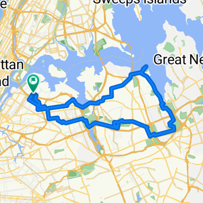
Our 5BBC Beach Bum ride begins with a ferry at 34 Street (connections are available at Corlears Hook and 96 St) to Ferry Point in Soundview. From there we move each to Throgs Neck, Locust Point, the coast along Schuylerville, Weir Creek, Park of Edgewater, Cherry Tree Point, Evers Marina, Huntington Woods, Pelham Bay Bridge, City Island, then Hunter Island and the Gray Mare, Twin Island (atr low tide), and, of coruse, Orchard Beach.
- -:--
- Duration
- 34.2 km
- Distance
- 75 m
- Ascent
- 76 m
- Descent
- ---
- Avg. speed
- ---
- Max. altitude
Continue with Bikemap
Use, edit, or download this cycling route
You would like to ride Orchard Beach or customize it for your own trip? Here is what you can do with this Bikemap route:
Free features
- Save this route as favorite or in collections
- Copy & plan your own version of this route
- Sync your route with Garmin or Wahoo
Premium features
Free trial for 3 days, or one-time payment. More about Bikemap Premium.
- Navigate this route on iOS & Android
- Export a GPX / KML file of this route
- Create your custom printout (try it for free)
- Download this route for offline navigation
Discover more Premium features.
Get Bikemap PremiumFrom our community
Other popular routes starting in Long Island City
- 122221 Downtown Brooklyn
- Distance
- 37.2 km
- Ascent
- 305 m
- Descent
- 303 m
- Location
- Long Island City, New York, United States
- 061520 BLM Street Art
- Distance
- 44.3 km
- Ascent
- 126 m
- Descent
- 126 m
- Location
- Long Island City, New York, United States
- 100m v1
- Distance
- 173.8 km
- Ascent
- 854 m
- Descent
- 854 m
- Location
- Long Island City, New York, United States
- GP to Coney along the Water Front
- Distance
- 27 km
- Ascent
- 96 m
- Descent
- 102 m
- Location
- Long Island City, New York, United States
- Oyster Bay North Shore 80
- Distance
- 129.4 km
- Ascent
- 357 m
- Descent
- 357 m
- Location
- Long Island City, New York, United States
- Queeeens
- Distance
- 20.4 km
- Ascent
- 56 m
- Descent
- 55 m
- Location
- Long Island City, New York, United States
- Perimeter Ride - Brooklyn NYC
- Distance
- 70.8 km
- Ascent
- 301 m
- Descent
- 309 m
- Location
- Long Island City, New York, United States
- 061420 Fort Totten
- Distance
- 30.3 km
- Ascent
- 93 m
- Descent
- 92 m
- Location
- Long Island City, New York, United States
Open it in the app