

laško-žalec
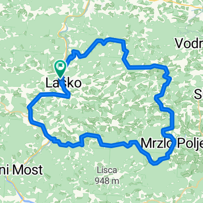
A cycling route starting in Laško, Laško Municipality, Slovenia.
Overview
About this route
- -:--
- Duration
- 40.9 km
- Distance
- 481 m
- Ascent
- 465 m
- Descent
- ---
- Avg. speed
- ---
- Max. altitude

Route quality
Waytypes & surfaces along the route
Waytypes
Road
18 km
(44 %)
Quiet road
17.6 km
(43 %)
Surfaces
Paved
20.5 km
(50 %)
Asphalt
20.5 km
(50 %)
Undefined
20.5 km
(50 %)
Continue with Bikemap
Use, edit, or download this cycling route
You would like to ride laško-žalec or customize it for your own trip? Here is what you can do with this Bikemap route:
Free features
- Save this route as favorite or in collections
- Copy & plan your own version of this route
- Sync your route with Garmin or Wahoo
Premium features
Free trial for 3 days, or one-time payment. More about Bikemap Premium.
- Navigate this route on iOS & Android
- Export a GPX / KML file of this route
- Create your custom printout (try it for free)
- Download this route for offline navigation
Discover more Premium features.
Get Bikemap PremiumFrom our community
Other popular routes starting in Laško
 Malič
Malič- Distance
- 9.6 km
- Ascent
- 706 m
- Descent
- 0 m
- Location
- Laško, Laško Municipality, Slovenia
 Hribovje nad Laškim
- Distance
- 52.9 km
- Ascent
- 739 m
- Descent
- 741 m
- Location
- Laško, Laško Municipality, Slovenia
 VI-Lj9: Rimske Toplice - Slovenska Bistrica, 70,1km 860hm
- Distance
- 70.1 km
- Ascent
- 1,125 m
- Descent
- 1,065 m
- Location
- Laško, Laško Municipality, Slovenia
 Jagoče - Svetina
- Distance
- 9.4 km
- Ascent
- 568 m
- Descent
- 105 m
- Location
- Laško, Laško Municipality, Slovenia
 Šmohor (4)
- Distance
- 26.3 km
- Ascent
- 633 m
- Descent
- 633 m
- Location
- Laško, Laško Municipality, Slovenia
 ALPEN 022: Rimske Toplice - Dravograd
- Distance
- 82.1 km
- Ascent
- 609 m
- Descent
- 483 m
- Location
- Laško, Laško Municipality, Slovenia
 Debro - Celjska Koča - Požnica - Reka - Laško
- Distance
- 25.2 km
- Ascent
- 577 m
- Descent
- 579 m
- Location
- Laško, Laško Municipality, Slovenia
 Laško -Zidani most-Laško
- Distance
- 29 km
- Ascent
- 238 m
- Descent
- 289 m
- Location
- Laško, Laško Municipality, Slovenia
Open it in the app