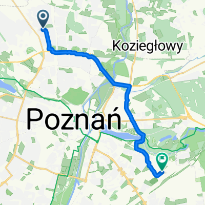
Sobieskiego - Strzeszynek
A cycling route starting in Suchy Las, Greater Poland Voivodeship, Poland.
Overview
About this route
by side roads
- -:--
- Duration
- 7.5 km
- Distance
- 33 m
- Ascent
- 30 m
- Descent
- ---
- Avg. speed
- ---
- Max. altitude
Route quality
Waytypes & surfaces along the route
Waytypes
Quiet road
2.2 km
(29 %)
Road
1.3 km
(17 %)
Surfaces
Paved
3.5 km
(46 %)
Unpaved
2.6 km
(34 %)
Asphalt
3.1 km
(41 %)
Gravel
1.1 km
(14 %)
Continue with Bikemap
Use, edit, or download this cycling route
You would like to ride Sobieskiego - Strzeszynek or customize it for your own trip? Here is what you can do with this Bikemap route:
Free features
- Save this route as favorite or in collections
- Copy & plan your own version of this route
- Sync your route with Garmin or Wahoo
Premium features
Free trial for 3 days, or one-time payment. More about Bikemap Premium.
- Navigate this route on iOS & Android
- Export a GPX / KML file of this route
- Create your custom printout (try it for free)
- Download this route for offline navigation
Discover more Premium features.
Get Bikemap PremiumFrom our community
Other popular routes starting in Suchy Las
- Sobieskiego - Strzeszynek
- Distance
- 7.5 km
- Ascent
- 33 m
- Descent
- 30 m
- Location
- Suchy Las, Greater Poland Voivodeship, Poland
- Pozna艅 - We艂na szuter
- Distance
- 110.5 km
- Ascent
- 322 m
- Descent
- 323 m
- Location
- Suchy Las, Greater Poland Voivodeship, Poland
- Podolany-P艂awno-S艂awa Wlkp (Bar Zapiecek!)-D膮br贸wka Ko艣cielna-Kozieg艂owy-Strzeszynek-Podolany
- Distance
- 101.2 km
- Ascent
- 282 m
- Descent
- 282 m
- Location
- Suchy Las, Greater Poland Voivodeship, Poland
- Paw艂owice 7.05.2022
- Distance
- 23.1 km
- Ascent
- 91 m
- Descent
- 90 m
- Location
- Suchy Las, Greater Poland Voivodeship, Poland
- Wok贸艂 Warty
- Distance
- 44.3 km
- Ascent
- 112 m
- Descent
- 111 m
- Location
- Suchy Las, Greater Poland Voivodeship, Poland
- Ucieczka z Pi膮tkowa
- Distance
- 33.9 km
- Ascent
- 132 m
- Descent
- 129 m
- Location
- Suchy Las, Greater Poland Voivodeship, Poland
- Ring 100KM
- Distance
- 95.5 km
- Ascent
- 480 m
- Descent
- 478 m
- Location
- Suchy Las, Greater Poland Voivodeship, Poland
- oborniki szosa
- Distance
- 78.2 km
- Ascent
- 219 m
- Descent
- 223 m
- Location
- Suchy Las, Greater Poland Voivodeship, Poland
Open it in the app