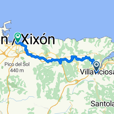
El Puntal
A cycling route starting in Villaviciosa, Principality of Asturias, Spain.
Overview
About this route
From Villaviciosa to El Puntal and back.
- -:--
- Duration
- 15.3 km
- Distance
- 42 m
- Ascent
- 42 m
- Descent
- ---
- Avg. speed
- ---
- Max. altitude
Route quality
Waytypes & surfaces along the route
Waytypes
- Road - 8.1 km - (53 %) 
- Quiet road - 1.5 km - (10 %) 
Surfaces
Paved
15.2 km
(99 %)
Unpaved
0.2 km
(1 %)
- Asphalt - 15.2 km - (99 %) 
- Gravel - 0.2 km - (1 %) 
Continue with Bikemap
Use, edit, or download this cycling route
You would like to ride El Puntal or customize it for your own trip? Here is what you can do with this Bikemap route:
Free features
- Save this route as favorite or in collections
- Copy & plan your own version of this route
- Sync your route with Garmin or Wahoo
Premium features
Free trial for 3 days, or one-time payment. More about Bikemap Premium.
- Navigate this route on iOS & Android
- Export a GPX / KML file of this route
- Create your custom printout (try it for free)
- Download this route for offline navigation
Discover more Premium features.
Get Bikemap PremiumFrom our community
Other popular routes starting in Villaviciosa
 Villaviciosa - Cabranes - Altu La Llama - Colunga - Llastres - Villaviciosa Villaviciosa - Cabranes - Altu La Llama - Colunga - Llastres - Villaviciosa- Distance
- 66.9 km
- Ascent
- 803 m
- Descent
- 802 m
- Location
- Villaviciosa, Principality of Asturias, Spain
 
 9 Villaviciosa - Ribadeo 9 Villaviciosa - Ribadeo- Distance
- 182.3 km
- Ascent
- 3,327 m
- Descent
- 3,293 m
- Location
- Villaviciosa, Principality of Asturias, Spain
 
 Camino Primitivo Fra kysten til Lugo Camino Primitivo Fra kysten til Lugo- Distance
- 270 km
- Ascent
- 2,891 m
- Descent
- 2,492 m
- Location
- Villaviciosa, Principality of Asturias, Spain
 
 El Puntal El Puntal- Distance
- 15.3 km
- Ascent
- 42 m
- Descent
- 42 m
- Location
- Villaviciosa, Principality of Asturias, Spain
 
 Villaviciosa Villaviciosa- Distance
- 85.2 km
- Ascent
- 1,054 m
- Descent
- 1,052 m
- Location
- Villaviciosa, Principality of Asturias, Spain
 
 Villaviciosa - Alto de La Llama Villaviciosa - Alto de La Llama- Distance
- 188.2 km
- Ascent
- 3,277 m
- Descent
- 2,877 m
- Location
- Villaviciosa, Principality of Asturias, Spain
 
 13.Faros del Norte: Playa de Rodiles (Villaviciosa) - faro de Tazones - Gijón 13.Faros del Norte: Playa de Rodiles (Villaviciosa) - faro de Tazones - Gijón- Distance
- 47.3 km
- Ascent
- 732 m
- Descent
- 666 m
- Location
- Villaviciosa, Principality of Asturias, Spain
 
 Selorio-Lastres-Colunga Selorio-Lastres-Colunga- Distance
- 25.2 km
- Ascent
- 494 m
- Descent
- 370 m
- Location
- Villaviciosa, Principality of Asturias, Spain
 
Open it in the app


