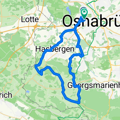
Brückenradweg
A cycling route starting in Osnabrück, Lower Saxony, Germany.
Overview
About this route
- -:--
- Duration
- 309.3 km
- Distance
- 234 m
- Ascent
- 235 m
- Descent
- ---
- Avg. speed
- ---
- Max. altitude
Route quality
Waytypes & surfaces along the route
Waytypes
Quiet road
185.6 km
(60 %)
Path
49.5 km
(16 %)
Surfaces
Paved
238.1 km
(77 %)
Unpaved
18.6 km
(6 %)
Asphalt
228.9 km
(74 %)
Gravel
12.4 km
(4 %)
Continue with Bikemap
Use, edit, or download this cycling route
You would like to ride Brückenradweg or customize it for your own trip? Here is what you can do with this Bikemap route:
Free features
- Save this route as favorite or in collections
- Copy & plan your own version of this route
- Split it into stages to create a multi-day tour
- Sync your route with Garmin or Wahoo
Premium features
Free trial for 3 days, or one-time payment. More about Bikemap Premium.
- Navigate this route on iOS & Android
- Export a GPX / KML file of this route
- Create your custom printout (try it for free)
- Download this route for offline navigation
Discover more Premium features.
Get Bikemap PremiumFrom our community
Other popular routes starting in Osnabrück
- Osn-Halen-Osn-4 Seen Tour
- Distance
- 31.4 km
- Ascent
- 132 m
- Descent
- 133 m
- Location
- Osnabrück, Lower Saxony, Germany
- Pfingstmontag Mühlentour
- Distance
- 30.3 km
- Ascent
- 181 m
- Descent
- 169 m
- Location
- Osnabrück, Lower Saxony, Germany
- Ausflug ins Grüne
- Distance
- 25.2 km
- Ascent
- 71 m
- Descent
- 67 m
- Location
- Osnabrück, Lower Saxony, Germany
- Moskau-Teuto1-Moskau
- Distance
- 49.2 km
- Ascent
- 619 m
- Descent
- 613 m
- Location
- Osnabrück, Lower Saxony, Germany
- kl. Feierabendrunde
- Distance
- 16.6 km
- Ascent
- 82 m
- Descent
- 80 m
- Location
- Osnabrück, Lower Saxony, Germany
- Piesberg
- Distance
- 10 km
- Ascent
- 187 m
- Descent
- 188 m
- Location
- Osnabrück, Lower Saxony, Germany
- Holte, Borgloh, Lienen, Hagen
- Distance
- 61.8 km
- Ascent
- 599 m
- Descent
- 574 m
- Location
- Osnabrück, Lower Saxony, Germany
- Piesberg-Nettetal-Tour CLONED FROM ROUTE 137918
- Distance
- 29 km
- Ascent
- 376 m
- Descent
- 373 m
- Location
- Osnabrück, Lower Saxony, Germany
Open it in the app