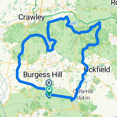
Clayton Road Ride to East
A cycling route starting in Hassocks, England, United Kingdom.
Overview
About this route
- -:--
- Duration
- 33.4 km
- Distance
- 196 m
- Ascent
- 193 m
- Descent
- ---
- Avg. speed
- ---
- Avg. speed
Route quality
Waytypes & surfaces along the route
Waytypes
Quiet road
14.4 km
(43 %)
Road
12.2 km
(37 %)
Surfaces
Paved
22.9 km
(69 %)
Asphalt
17.4 km
(52 %)
Paved (undefined)
5.6 km
(17 %)
Undefined
10.5 km
(31 %)
Continue with Bikemap
Use, edit, or download this cycling route
You would like to ride Clayton Road Ride to East or customize it for your own trip? Here is what you can do with this Bikemap route:
Free features
- Save this route as favorite or in collections
- Copy & plan your own version of this route
- Sync your route with Garmin or Wahoo
Premium features
Free trial for 3 days, or one-time payment. More about Bikemap Premium.
- Navigate this route on iOS & Android
- Export a GPX / KML file of this route
- Create your custom printout (try it for free)
- Download this route for offline navigation
Discover more Premium features.
Get Bikemap PremiumFrom our community
Other popular routes starting in Hassocks
- wiatraki wiatraki
- Distance
- 32.8 km
- Ascent
- 349 m
- Descent
- 350 m
- Location
- Hassocks, England, United Kingdom
- Hassocks-Fulking-Lewes-60kms
- Distance
- 61.3 km
- Ascent
- 932 m
- Descent
- 931 m
- Location
- Hassocks, England, United Kingdom
- Easy ride in United Kingdom
- Distance
- 25.9 km
- Ascent
- 162 m
- Descent
- 163 m
- Location
- Hassocks, England, United Kingdom
- Herstmonceux Route
- Distance
- 121 km
- Ascent
- 348 m
- Descent
- 370 m
- Location
- Hassocks, England, United Kingdom
- Clayton Road Ride to East
- Distance
- 33.4 km
- Ascent
- 196 m
- Descent
- 193 m
- Location
- Hassocks, England, United Kingdom
- Ditchling Waldron Forest row loop
- Distance
- 104.5 km
- Ascent
- 596 m
- Descent
- 596 m
- Location
- Hassocks, England, United Kingdom
- Puncheur 2013 (unofficial)2
- Distance
- 108.8 km
- Ascent
- 1,102 m
- Descent
- 1,087 m
- Location
- Hassocks, England, United Kingdom
- sdw9
- Distance
- 18 km
- Ascent
- 255 m
- Descent
- 460 m
- Location
- Hassocks, England, United Kingdom
Open it in the app