

Weidatal MTB Marathon
A cycling route starting in Weißendorf, Thuringia, Germany.
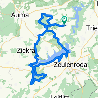
Overview
About this route
- -:--
- Duration
- 33.3 km
- Distance
- 447 m
- Ascent
- 447 m
- Descent
- ---
- Avg. speed
- ---
- Max. altitude

Continue with Bikemap
Use, edit, or download this cycling route
You would like to ride Weidatal MTB Marathon or customize it for your own trip? Here is what you can do with this Bikemap route:
Free features
- Save this route as favorite or in collections
- Copy & plan your own version of this route
- Sync your route with Garmin or Wahoo
Premium features
Free trial for 3 days, or one-time payment. More about Bikemap Premium.
- Navigate this route on iOS & Android
- Export a GPX / KML file of this route
- Create your custom printout (try it for free)
- Download this route for offline navigation
Discover more Premium features.
Get Bikemap PremiumFrom our community
Other popular routes starting in Weißendorf
 Merken 32, Zeulenroda-Triebes nach Merken 32, Zeulenroda-Triebes
- Distance
- 33.2 km
- Ascent
- 481 m
- Descent
- 479 m
- Location
- Weißendorf, Thuringia, Germany
 Merken 48, Zeulenroda-Triebes nach Merken 57, Zeulenroda-Triebes
- Distance
- 35.5 km
- Ascent
- 593 m
- Descent
- 585 m
- Location
- Weißendorf, Thuringia, Germany
 Herbsttour 171015
- Distance
- 61.7 km
- Ascent
- 778 m
- Descent
- 769 m
- Location
- Weißendorf, Thuringia, Germany
 Merken 32, Zeulenroda-Triebes nach Merken 32, Zeulenroda-Triebes
- Distance
- 21.9 km
- Ascent
- 545 m
- Descent
- 547 m
- Location
- Weißendorf, Thuringia, Germany
 Talsperrenrunde BikeHouse
- Distance
- 34.7 km
- Ascent
- 532 m
- Descent
- 526 m
- Location
- Weißendorf, Thuringia, Germany
 Merken, Zeulenroda-Triebes nach Merken, Zeulenroda-Triebes
- Distance
- 34.5 km
- Ascent
- 559 m
- Descent
- 553 m
- Location
- Weißendorf, Thuringia, Germany
 Tag2 (1) Piesigitz-Abhorn
- Distance
- 46 km
- Ascent
- 575 m
- Descent
- 512 m
- Location
- Weißendorf, Thuringia, Germany
 Merken 32, Zeulenroda-Triebes nach Merken 32, Zeulenroda-Triebes
- Distance
- 30.2 km
- Ascent
- 455 m
- Descent
- 457 m
- Location
- Weißendorf, Thuringia, Germany
Open it in the app