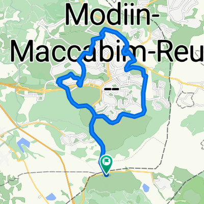
LTR-NES
A cycling route starting in Bayt Sīrā, West Bank, Palestine.
Overview
About this route
- -:--
- Duration
- 94.7 km
- Distance
- 915 m
- Ascent
- 916 m
- Descent
- ---
- Avg. speed
- ---
- Max. altitude
Route quality
Waytypes & surfaces along the route
Waytypes
Cycleway
27.4 km
(29 %)
Track
26.5 km
(28 %)
Surfaces
Paved
40.7 km
(43 %)
Unpaved
0.9 km
(1 %)
Asphalt
36 km
(38 %)
Concrete
4.7 km
(5 %)
Continue with Bikemap
Use, edit, or download this cycling route
You would like to ride LTR-NES or customize it for your own trip? Here is what you can do with this Bikemap route:
Free features
- Save this route as favorite or in collections
- Copy & plan your own version of this route
- Split it into stages to create a multi-day tour
- Sync your route with Garmin or Wahoo
Premium features
Free trial for 3 days, or one-time payment. More about Bikemap Premium.
- Navigate this route on iOS & Android
- Export a GPX / KML file of this route
- Create your custom printout (try it for free)
- Download this route for offline navigation
Discover more Premium features.
Get Bikemap PremiumFrom our community
Other popular routes starting in Bayt Sīrā
- latrun-2, 17k 120m
- Distance
- 17.2 km
- Ascent
- 184 m
- Descent
- 194 m
- Location
- Bayt Sīrā, West Bank, Palestine
- EPIC1902
- Distance
- 69.1 km
- Ascent
- 1,099 m
- Descent
- 1,097 m
- Location
- Bayt Sīrā, West Bank, Palestine
- Moderate ride to Roman baths
- Distance
- 11.6 km
- Ascent
- 233 m
- Descent
- 246 m
- Location
- Bayt Sīrā, West Bank, Palestine
- שדרות יצחק רבין 46, מודיעין מכבים רעות to נחל נעמן 22, מודיעין מכבים רעות
- Distance
- 30.1 km
- Ascent
- 125 m
- Descent
- 239 m
- Location
- Bayt Sīrā, West Bank, Palestine
- LTR-NES
- Distance
- 94.7 km
- Ascent
- 915 m
- Descent
- 916 m
- Location
- Bayt Sīrā, West Bank, Palestine
- סינגל הגורל השביעי
- Distance
- 7.9 km
- Ascent
- 233 m
- Descent
- 247 m
- Location
- Bayt Sīrā, West Bank, Palestine
- ריצה:במודיעין
- Distance
- 16.3 km
- Ascent
- 365 m
- Descent
- 374 m
- Location
- Bayt Sīrā, West Bank, Palestine
- latrun
- Distance
- 30.4 km
- Ascent
- 236 m
- Descent
- 236 m
- Location
- Bayt Sīrā, West Bank, Palestine
Open it in the app