via verde ojos negros - cudiel - navajas
A cycling route starting in Jérica, Valencia, Spain.
Overview
About this route
- -:--
- Duration
- 16.4 km
- Distance
- 101 m
- Ascent
- 357 m
- Descent
- ---
- Avg. speed
- ---
- Max. altitude
Route quality
Waytypes & surfaces along the route
Waytypes
Track
9.3 km
(57 %)
Access road
3.8 km
(23 %)
Surfaces
Paved
13.4 km
(82 %)
Paved (undefined)
12.1 km
(74 %)
Asphalt
1.3 km
(8 %)
Undefined
3 km
(18 %)
Continue with Bikemap
Use, edit, or download this cycling route
You would like to ride via verde ojos negros - cudiel - navajas or customize it for your own trip? Here is what you can do with this Bikemap route:
Free features
- Save this route as favorite or in collections
- Copy & plan your own version of this route
- Sync your route with Garmin or Wahoo
Premium features
Free trial for 3 days, or one-time payment. More about Bikemap Premium.
- Navigate this route on iOS & Android
- Export a GPX / KML file of this route
- Create your custom printout (try it for free)
- Download this route for offline navigation
Discover more Premium features.
Get Bikemap PremiumFrom our community
Other popular routes starting in Jérica
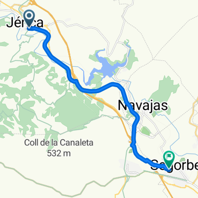
- RUTA MINA DE OJOS NEGROS, TRAMO JERICA-BARRACAS
- Distance
- 31.2 km
- Ascent
- 549 m
- Descent
- 45 m
- Location
- Jérica, Valencia, Spain
- ESP 033: Via Verde Ojos Negros (Südabschnitt- 2. Teil)
- Distance
- 87.7 km
- Ascent
- 702 m
- Descent
- 702 m
- Location
- Jérica, Valencia, Spain
- Caudiel, Alcabaira, Maspalomas, Cerdaña, Fuensanta
- Distance
- 24 km
- Ascent
- 646 m
- Descent
- 647 m
- Location
- Jérica, Valencia, Spain
- Jérica-OF Feliciano-OF Peñas Amador
- Distance
- 56.6 km
- Ascent
- 1,163 m
- Descent
- 1,163 m
- Location
- Jérica, Valencia, Spain
- ESP 034: Via Verde Ojos Negros (Südabschnitt- 3. Teil)
- Distance
- 82.1 km
- Ascent
- 826 m
- Descent
- 827 m
- Location
- Jérica, Valencia, Spain
- Jérica-Montanejos-Villahermosa-Montanejos-Jérica
- Distance
- 112.6 km
- Ascent
- 3,534 m
- Descent
- 3,437 m
- Location
- Jérica, Valencia, Spain
- Jérica-Paisajes del Palancia
- Distance
- 34.7 km
- Ascent
- 357 m
- Descent
- 357 m
- Location
- Jérica, Valencia, Spain
- Paisajes del Río Palancia
- Distance
- 29.1 km
- Ascent
- 407 m
- Descent
- 397 m
- Location
- Jérica, Valencia, Spain
Open it in the app