
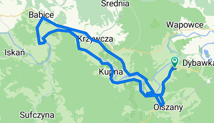
OKOLO SANU II - 2. deň
A cycling route starting in Krasiczyn, Subcarpathian Voivodeship, Poland.
Overview
About this route
asfalt, poľná cesta
- -:--
- Duration
- 46.7 km
- Distance
- 375 m
- Ascent
- 375 m
- Descent
- ---
- Avg. speed
- ---
- Max. altitude

Route quality
Waytypes & surfaces along the route
Waytypes
Quiet road
29 km
(62 %)
Track
3.3 km
(7 %)
Surfaces
Paved
39.3 km
(84 %)
Unpaved
2.3 km
(5 %)
Asphalt
37.9 km
(81 %)
Gravel
1.4 km
(3 %)
Continue with Bikemap
Use, edit, or download this cycling route
You would like to ride OKOLO SANU II - 2. deň or customize it for your own trip? Here is what you can do with this Bikemap route:
Free features
- Save this route as favorite or in collections
- Copy & plan your own version of this route
- Sync your route with Garmin or Wahoo
Premium features
Free trial for 3 days, or one-time payment. More about Bikemap Premium.
- Navigate this route on iOS & Android
- Export a GPX / KML file of this route
- Create your custom printout (try it for free)
- Download this route for offline navigation
Discover more Premium features.
Get Bikemap PremiumFrom our community
Other popular routes starting in Krasiczyn
 OKOLO SANU II - 4.deň
- Distance
- 57.8 km
- Ascent
- 903 m
- Descent
- 891 m
- Location
- Krasiczyn, Subcarpathian Voivodeship, Poland
 VI TRR Etap 8A - Wapowce-Postołów
- Distance
- 86 km
- Ascent
- 498 m
- Descent
- 380 m
- Location
- Krasiczyn, Subcarpathian Voivodeship, Poland
 W010 Dybawka Rabe
- Distance
- 84.4 km
- Ascent
- 1,101 m
- Descent
- 760 m
- Location
- Krasiczyn, Subcarpathian Voivodeship, Poland
 OKOLO SANU II - 1. deň
- Distance
- 24.8 km
- Ascent
- 399 m
- Descent
- 400 m
- Location
- Krasiczyn, Subcarpathian Voivodeship, Poland
 Perły Podk-5
- Distance
- 80.7 km
- Ascent
- 247 m
- Descent
- 263 m
- Location
- Krasiczyn, Subcarpathian Voivodeship, Poland
 Karpaty Polskie - 11
- Distance
- 107.3 km
- Ascent
- 750 m
- Descent
- 710 m
- Location
- Krasiczyn, Subcarpathian Voivodeship, Poland
 OKOLO SANU II - 2. deň
- Distance
- 46.7 km
- Ascent
- 375 m
- Descent
- 375 m
- Location
- Krasiczyn, Subcarpathian Voivodeship, Poland
 Dybawka - Krasiczyn - Bircza - Iskań - Piątkowa - Iskań - Bachórzec - Babice - Korytniki - Krasiczyn -Dybawka
- Distance
- 91 km
- Ascent
- 767 m
- Descent
- 767 m
- Location
- Krasiczyn, Subcarpathian Voivodeship, Poland
Open it in the app