

GTMC
Ruynes-en-Margeride / Domaine du Sauvage
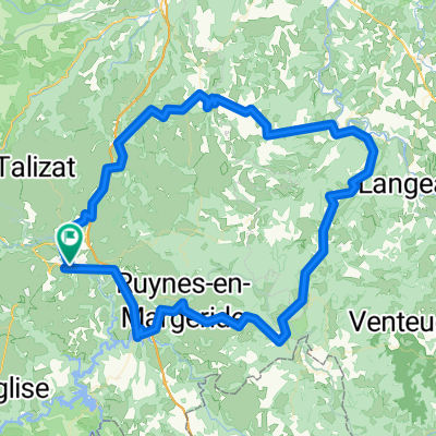
A cycling route starting in Saint-Flour, Auvergne-Rhône-Alpes, France.
Overview
About this route
From Ruynes in Margeride, you need to climb the elevation to Trailus and then ascend to the Col du Signal. Then follows a rather rolling ridge path that leads to the summit of Mont Mouchet (1497 m), a significant site of the French Resistance. You then enter Haute-Loire and then descend to Paulhac in Margeride, located in Lozère. The forest paths that carve through these wooded and granitic landscapes lead to the Domaine du Sauvage, an old Templar dormitory, a major stop on the Camino de Santiago.
Departure from Ruynes: steep ascent on forest paths to the ridges. Rolling path from Col du Signal to the cross of Donne with pretty views. A small stretch of road to reach the Museum of Mont Mouchet. Rolling path alternating between forest and open terrain to the summit of Mont Mouchet (views and orientation table). Fast descent to Paulhac and then we take wide paths between pastures and pine forests until Chanaleilles. A small stretch of road with a gentle incline to climb up to Chazeaux. Forest path on the GR 65 at the end of the stage to reach the Domaine du Sauvage.
- -:--
- Duration
- 48.2 km
- Distance
- 1,444 m
- Ascent
- 1,019 m
- Descent
- ---
- Avg. speed
- ---
- Max. altitude

Part of
6 stages
Route quality
Waytypes & surfaces along the route
Waytypes
Track
35.7 km
(74 %)
Quiet road
7.2 km
(15 %)
Surfaces
Paved
0.5 km
(1 %)
Unpaved
30.4 km
(63 %)
Gravel
21.2 km
(44 %)
Unpaved (undefined)
6.7 km
(14 %)
Continue with Bikemap
Use, edit, or download this cycling route
You would like to ride Ruynes-en-Margeride / Domaine du Sauvage or customize it for your own trip? Here is what you can do with this Bikemap route:
Free features
- Save this route as favorite or in collections
- Copy & plan your own version of this route
- Sync your route with Garmin or Wahoo
Premium features
Free trial for 3 days, or one-time payment. More about Bikemap Premium.
- Navigate this route on iOS & Android
- Export a GPX / KML file of this route
- Create your custom printout (try it for free)
- Download this route for offline navigation
Discover more Premium features.
Get Bikemap PremiumFrom our community
Other popular routes starting in Saint-Flour
 Paris - Nice : 4. Saint-Flour - Mont Aigoual
- Distance
- 205.1 km
- Ascent
- 3,250 m
- Descent
- 2,700 m
- Location
- Saint-Flour, Auvergne-Rhône-Alpes, France
 courage les mecs
- Distance
- 57.4 km
- Ascent
- 531 m
- Descent
- 532 m
- Location
- Saint-Flour, Auvergne-Rhône-Alpes, France
 Massif Central 2009 - Tour 2 - Granitberge der Margeride
- Distance
- 115.7 km
- Ascent
- 2,301 m
- Descent
- 2,356 m
- Location
- Saint-Flour, Auvergne-Rhône-Alpes, France
 Ruynes-en-Margeride / Domaine du Sauvage
- Distance
- 48.2 km
- Ascent
- 1,444 m
- Descent
- 1,019 m
- Location
- Saint-Flour, Auvergne-Rhône-Alpes, France
 SF-Super Lioran-Mandailles-Dienne-SF
- Distance
- 119.8 km
- Ascent
- 1,946 m
- Descent
- 1,947 m
- Location
- Saint-Flour, Auvergne-Rhône-Alpes, France
 Ruynes-en-Margeride - Saugues (Nr. 152)
- Distance
- 37.5 km
- Ascent
- 675 m
- Descent
- 611 m
- Location
- Saint-Flour, Auvergne-Rhône-Alpes, France
 Les Gorges de la Truyère
- Distance
- 54.3 km
- Ascent
- 1,005 m
- Descent
- 1,005 m
- Location
- Saint-Flour, Auvergne-Rhône-Alpes, France
 Massif Central 2009 - Tour 4 - Zum Plomb du Cantal
- Distance
- 114.1 km
- Ascent
- 2,977 m
- Descent
- 2,893 m
- Location
- Saint-Flour, Auvergne-Rhône-Alpes, France
Open it in the app