

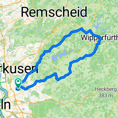
Köln-Mülheim - Seelscheid - Much - Rösrath - Köln-Mülheim
A cycling route starting in Mülheim, North Rhine-Westphalia, Germany.
Overview
About this route
Es geht von Köln-Mülheim aus durch die schöne Wahner Heide, über steile Serpentinen hoch nach Seelscheid.
Von dort aus fährt man bergab, wo sich in Gutmühle mit der Auszeit eine Rastmöglichkeit bietet. Wieder bergauf geht es auf der Höhe bis Kreuzkapelle, wo man auf dem Herrenteich rudern kann.
Nach Much geht es wieder bergauf, was herrliche Blicke über Köln und die Kölner Bucht möglich macht. Durch Rörath geht es bergab wieder zurück nach Köln.
- -:--
- Duration
- 92.6 km
- Distance
- 613 m
- Ascent
- 617 m
- Descent
- ---
- Avg. speed
- ---
- Max. altitude
Route quality
Waytypes & surfaces along the route
Waytypes
Quiet road
26.9 km
(29 %)
Path
25.8 km
(28 %)
Surfaces
Paved
65.8 km
(71 %)
Unpaved
7.9 km
(9 %)
Asphalt
60.7 km
(66 %)
Gravel
3.5 km
(4 %)
Continue with Bikemap
Use, edit, or download this cycling route
You would like to ride Köln-Mülheim - Seelscheid - Much - Rösrath - Köln-Mülheim or customize it for your own trip? Here is what you can do with this Bikemap route:
Free features
- Save this route as favorite or in collections
- Copy & plan your own version of this route
- Split it into stages to create a multi-day tour
- Sync your route with Garmin or Wahoo
Premium features
Free trial for 3 days, or one-time payment. More about Bikemap Premium.
- Navigate this route on iOS & Android
- Export a GPX / KML file of this route
- Create your custom printout (try it for free)
- Download this route for offline navigation
Discover more Premium features.
Get Bikemap PremiumFrom our community
Other popular routes starting in Mülheim
 E- Bike Bergisch Gladgach auch für das Trekkingbike geeignet.
- Distance
- 44.7 km
- Ascent
- 439 m
- Descent
- 437 m
- Location
- Mülheim, North Rhine-Westphalia, Germany
 Tour nach Bechen
- Distance
- 48.3 km
- Ascent
- 534 m
- Descent
- 534 m
- Location
- Mülheim, North Rhine-Westphalia, Germany
 warmrollen im bergischen land
- Distance
- 141.9 km
- Ascent
- 1,037 m
- Descent
- 1,037 m
- Location
- Mülheim, North Rhine-Westphalia, Germany
 Balkantrasse bis Bergisch Born nach Lennep.
- Distance
- 73.5 km
- Ascent
- 424 m
- Descent
- 402 m
- Location
- Mülheim, North Rhine-Westphalia, Germany
 Neue Route durch den Königsforst
- Distance
- 69.1 km
- Ascent
- 244 m
- Descent
- 223 m
- Location
- Mülheim, North Rhine-Westphalia, Germany
 Dünnthalsperren-Tour
- Distance
- 52.3 km
- Ascent
- 524 m
- Descent
- 510 m
- Location
- Mülheim, North Rhine-Westphalia, Germany
 Runde zum Fit bleiben
- Distance
- 34.9 km
- Ascent
- 375 m
- Descent
- 376 m
- Location
- Mülheim, North Rhine-Westphalia, Germany
 RTF Köln (Ford) 2007 2Pkt
- Distance
- 74.9 km
- Ascent
- 726 m
- Descent
- 703 m
- Location
- Mülheim, North Rhine-Westphalia, Germany
Open it in the app