

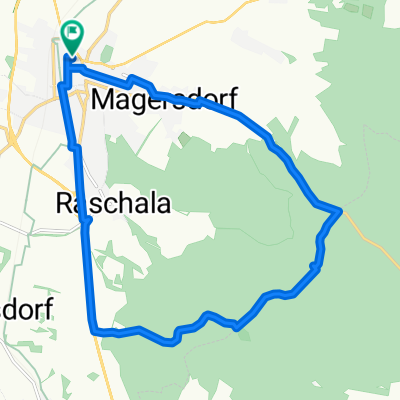
HL West
A cycling route starting in Hollabrunn, Lower Austria, Austria.
Overview
About this route
Von der Alten Hofmühle in Hollabrunn durch die Sitzendorfer Kellergasse über Klein Maria Dreieichen nach Groß. Hintaus nach Kleinstelzendorf und weiter entlang des Waldstücks nach Hollenstein. Aufstieg durch die Weingärten und weiter zum Köhlberg und Abfahrt über den Hundsberg nach Rohrbach. Durch die Kellergasse zu Schober's Weinbrunnen und weiter zum Roten Kreuz. Auf dem Hochweg durch den Wald nach Wolfbrunn und entlang des Runzenbaches zurück nach Hollabrunn auf einen ausgezeichneten Radler in das Gasthaus zum Goldenen Stern (Familie Graf). Prost!
- -:--
- Duration
- 37.9 km
- Distance
- 434 m
- Ascent
- 445 m
- Descent
- ---
- Avg. speed
- ---
- Max. altitude
Route quality
Waytypes & surfaces along the route
Waytypes
Track
28.1 km
(74 %)
Quiet road
6.8 km
(18 %)
Surfaces
Paved
13.7 km
(36 %)
Unpaved
20.1 km
(53 %)
Gravel
12.5 km
(33 %)
Asphalt
8.3 km
(22 %)
Continue with Bikemap
Use, edit, or download this cycling route
You would like to ride HL West or customize it for your own trip? Here is what you can do with this Bikemap route:
Free features
- Save this route as favorite or in collections
- Copy & plan your own version of this route
- Sync your route with Garmin or Wahoo
Premium features
Free trial for 3 days, or one-time payment. More about Bikemap Premium.
- Navigate this route on iOS & Android
- Export a GPX / KML file of this route
- Create your custom printout (try it for free)
- Download this route for offline navigation
Discover more Premium features.
Get Bikemap PremiumFrom our community
Other popular routes starting in Hollabrunn
 Samstag: Suttenbrunn-Großwetzdorf-Straning-Sitzendorf a. d. Schmida
- Distance
- 71.9 km
- Ascent
- 704 m
- Descent
- 704 m
- Location
- Hollabrunn, Lower Austria, Austria
 Leichte Weinviertelrunde
- Distance
- 170.9 km
- Ascent
- 1,045 m
- Descent
- 1,045 m
- Location
- Hollabrunn, Lower Austria, Austria
 Rivanerweg lt Radwegauszeichnung
- Distance
- 54.8 km
- Ascent
- 396 m
- Descent
- 397 m
- Location
- Hollabrunn, Lower Austria, Austria
 Test Grünes Kreuz
- Distance
- 15.8 km
- Ascent
- 182 m
- Descent
- 180 m
- Location
- Hollabrunn, Lower Austria, Austria
 Mittwoch: Kellertrift Heuriger Loiskandl
- Distance
- 13.5 km
- Ascent
- 85 m
- Descent
- 83 m
- Location
- Hollabrunn, Lower Austria, Austria
 hollabrunn-marchegg
- Distance
- 103.4 km
- Ascent
- 385 m
- Descent
- 461 m
- Location
- Hollabrunn, Lower Austria, Austria
 Hollabrunn-Altenmarkt-Viendorf-Hollabrunn
- Distance
- 41.1 km
- Ascent
- 201 m
- Descent
- 201 m
- Location
- Hollabrunn, Lower Austria, Austria
 Abendtour
- Distance
- 27.8 km
- Ascent
- 245 m
- Descent
- 253 m
- Location
- Hollabrunn, Lower Austria, Austria
Open it in the app