
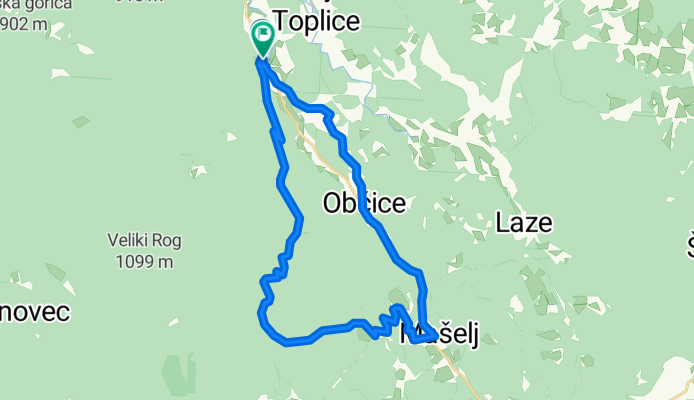
Podturn - Baza 20 - Črmošnjice
A cycling route starting in Dolenjske Toplice, Dolenjske Toplice, Slovenia.
Overview
About this route
- -:--
- Duration
- 28.4 km
- Distance
- 686 m
- Ascent
- 688 m
- Descent
- ---
- Avg. speed
- ---
- Max. altitude

Route quality
Waytypes & surfaces along the route
Waytypes
Quiet road
18 km
(64 %)
Busy road
4.5 km
(16 %)
Surfaces
Paved
14.9 km
(53 %)
Unpaved
6.3 km
(22 %)
Asphalt
14.9 km
(53 %)
Gravel
5.6 km
(20 %)
Continue with Bikemap
Use, edit, or download this cycling route
You would like to ride Podturn - Baza 20 - Črmošnjice or customize it for your own trip? Here is what you can do with this Bikemap route:
Free features
- Save this route as favorite or in collections
- Copy & plan your own version of this route
- Sync your route with Garmin or Wahoo
Premium features
Free trial for 3 days, or one-time payment. More about Bikemap Premium.
- Navigate this route on iOS & Android
- Export a GPX / KML file of this route
- Create your custom printout (try it for free)
- Download this route for offline navigation
Discover more Premium features.
Get Bikemap PremiumFrom our community
Other popular routes starting in Dolenjske Toplice
 Pajkež--29.3.2020
- Distance
- 23 km
- Ascent
- 636 m
- Descent
- 635 m
- Location
- Dolenjske Toplice, Dolenjske Toplice, Slovenia
 Dolenjske Toplice-Dolenjske Toplice
- Distance
- 107.8 km
- Ascent
- 827 m
- Descent
- 827 m
- Location
- Dolenjske Toplice, Dolenjske Toplice, Slovenia
 Ptuj-Piran 3D K
- Distance
- 68.2 km
- Ascent
- 903 m
- Descent
- 302 m
- Location
- Dolenjske Toplice, Dolenjske Toplice, Slovenia
 21.10.2017
- Distance
- 39.7 km
- Ascent
- 370 m
- Descent
- 371 m
- Location
- Dolenjske Toplice, Dolenjske Toplice, Slovenia
 Goričko-Piran 3D
- Distance
- 70.7 km
- Ascent
- 1,411 m
- Descent
- 1,293 m
- Location
- Dolenjske Toplice, Dolenjske Toplice, Slovenia
 Dolenjske Toplice - 2
- Distance
- 44.6 km
- Ascent
- 1,177 m
- Descent
- 1,133 m
- Location
- Dolenjske Toplice, Dolenjske Toplice, Slovenia
 Doleske toplice - Mirna gora krog
- Distance
- 50.9 km
- Ascent
- 1,049 m
- Descent
- 1,049 m
- Location
- Dolenjske Toplice, Dolenjske Toplice, Slovenia
 SK - IT 5v5 Day 5
- Distance
- 147.4 km
- Ascent
- 1,050 m
- Descent
- 902 m
- Location
- Dolenjske Toplice, Dolenjske Toplice, Slovenia
Open it in the app