Etapa 6: A Baux du Provence
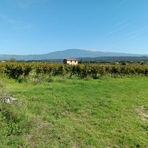
A cycling route starting in Mazan, Provence-Alpes-C么te d'Azur Region, France.
Overview
About this route
It is made from Mazan through beautiful towns.
- -:--
- Duration
- 102.8 km
- Distance
- 1,047 m
- Ascent
- 996 m
- Descent
- ---
- Avg. speed
- ---
- Max. altitude
Route quality
Waytypes & surfaces along the route
Waytypes
Road
45.2 km
(44 %)
Quiet road
23.7 km
(23 %)
Surfaces
Paved
65.8 km
(64 %)
Unpaved
2.1 km
(2 %)
Asphalt
65.8 km
(64 %)
Gravel
1 km
(1 %)
Continue with Bikemap
Use, edit, or download this cycling route
You would like to ride Etapa 6: A Baux du Provence or customize it for your own trip? Here is what you can do with this Bikemap route:
Free features
- Save this route as favorite or in collections
- Copy & plan your own version of this route
- Split it into stages to create a multi-day tour
- Sync your route with Garmin or Wahoo
Premium features
Free trial for 3 days, or one-time payment. More about Bikemap Premium.
- Navigate this route on iOS & Android
- Export a GPX / KML file of this route
- Create your custom printout (try it for free)
- Download this route for offline navigation
Discover more Premium features.
Get Bikemap PremiumFrom our community
Other popular routes starting in Mazan
tour gorge de la nesque- Distance
- 84.3 km
- Ascent
- 1,406 m
- Descent
- 1,405 m
- Location
- Mazan, Provence-Alpes-C么te d'Azur Region, France
Rund um den Mont Ventoux- Distance
- 120.8 km
- Ascent
- 1,108 m
- Descent
- 1,106 m
- Location
- Mazan, Provence-Alpes-C么te d'Azur Region, France
Mazan a vinice na sever- Distance
- 39.6 km
- Ascent
- 407 m
- Descent
- 418 m
- Location
- Mazan, Provence-Alpes-C么te d'Azur Region, France
6-MAZAN-GORGES DE LA NESQUE- Distance
- 69.8 km
- Ascent
- 1,196 m
- Descent
- 1,199 m
- Location
- Mazan, Provence-Alpes-C么te d'Azur Region, France
Provence_2020_2: Gorges de la Nesque- Distance
- 79.6 km
- Ascent
- 886 m
- Descent
- 888 m
- Location
- Mazan, Provence-Alpes-C么te d'Azur Region, France
Avenue de l'Europe nach Route de Crillon- Distance
- 9.8 km
- Ascent
- 256 m
- Descent
- 159 m
- Location
- Mazan, Provence-Alpes-C么te d'Azur Region, France
Mazan to Il de sur kolecko- Distance
- 46.6 km
- Ascent
- 410 m
- Descent
- 405 m
- Location
- Mazan, Provence-Alpes-C么te d'Azur Region, France
Fabians M枚rderroute- Distance
- 160.6 km
- Ascent
- 4,335 m
- Descent
- 4,335 m
- Location
- Mazan, Provence-Alpes-C么te d'Azur Region, France
Open it in the app


