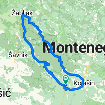
Črna Gora - Kolašin - Žabljak
A cycling route starting in Kolašin, Opština Kolašin, Montenegro.
Overview
About this route
Translated, show original (Polish)
- -:--
- Duration
- 67.1 km
- Distance
- 1,537 m
- Ascent
- 1,723 m
- Descent
- ---
- Avg. speed
- 958 m
- Max. altitude
Route quality
Waytypes & surfaces along the route
Waytypes
- Quiet road - 0.7 km - (1 %) 
- Undefined - 66.5 km - (99 %) 
Surfaces
Paved
66.5 km
(99 %)
- Asphalt - 66.5 km - (99 %) 
- Undefined - 0.7 km - (1 %) 
Continue with Bikemap
Use, edit, or download this cycling route
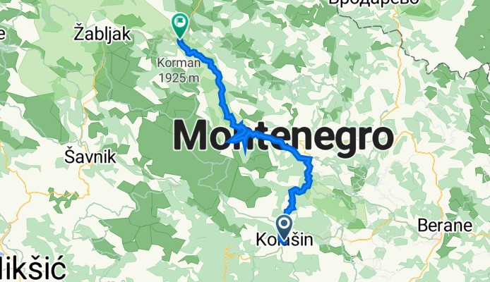
You would like to ride Črna Gora - Kolašin - Žabljak or customize it for your own trip? Here is what you can do with this Bikemap route:
Free features
- Save this route as favorite or in collections
- Copy & plan your own version of this route
- Sync your route with Garmin or Wahoo
Premium features
Free trial for 3 days, or one-time payment. More about Bikemap Premium.
- Navigate this route on iOS & Android
- Export a GPX / KML file of this route
- Create your custom printout (try it for free)
- Download this route for offline navigation
Discover more Premium features.
Get Bikemap PremiumFrom our community
Other popular routes starting in Kolašin
 ASL09-010-prijezd do Podgorice ASL09-010-prijezd do Podgorice- Distance
- 58.9 km
- Ascent
- 581 m
- Descent
- 1,441 m
- Location
- Kolašin, Opština Kolašin, Montenegro
 
 Kolasin - Virpasar Kolasin - Virpasar- Distance
- 112.9 km
- Ascent
- 946 m
- Descent
- 1,887 m
- Location
- Kolašin, Opština Kolašin, Montenegro
 
 5. Veruša 5. Veruša- Distance
- 64.1 km
- Ascent
- 894 m
- Descent
- 2,056 m
- Location
- Kolašin, Opština Kolašin, Montenegro
 
 Kolašin - Mojkovac Kolašin - Mojkovac- Distance
- 44.5 km
- Ascent
- 1,566 m
- Descent
- 621 m
- Location
- Kolašin, Opština Kolašin, Montenegro
 
 10 Day Montenegro MTN Bike 10 Day Montenegro MTN Bike- Distance
- 203.8 km
- Ascent
- 5,992 m
- Descent
- 7,100 m
- Location
- Kolašin, Opština Kolašin, Montenegro
 
 CH6 Kolasin okruh CH6 Kolasin okruh- Distance
- 57.8 km
- Ascent
- 1,111 m
- Descent
- 1,111 m
- Location
- Kolašin, Opština Kolašin, Montenegro
 
 Gornja Morača, Žabljak, Sinjavina, Kolašin, Mioska Gornja Morača, Žabljak, Sinjavina, Kolašin, Mioska- Distance
- 148.3 km
- Ascent
- 2,227 m
- Descent
- 2,255 m
- Location
- Kolašin, Opština Kolašin, Montenegro
 
 MONTENEGRO - TAPPA 3 - 23/08/2015 MONTENEGRO - TAPPA 3 - 23/08/2015- Distance
- 82.7 km
- Ascent
- 941 m
- Descent
- 1,843 m
- Location
- Kolašin, Opština Kolašin, Montenegro
 
Open it in the app


