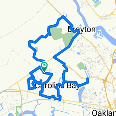
Get Over It - Extended Route
A cycling route starting in Shell Point, South Carolina, United States.
Overview
About this route
Stono River to Red's Ice House @ Shem Creek
- -:--
- Duration
- 50.2 km
- Distance
- 73 m
- Ascent
- 73 m
- Descent
- ---
- Avg. speed
- ---
- Max. altitude
Route quality
Waytypes & surfaces along the route
Waytypes
Cycleway
35.7 km
(71 %)
Quiet road
5.5 km
(11 %)
Surfaces
Paved
21.6 km
(43 %)
Unpaved
4 km
(8 %)
Asphalt
21.6 km
(43 %)
Ground
4 km
(8 %)
Undefined
24.6 km
(49 %)
Route highlights
Points of interest along the route
Point of interest after 17.1 km
Continue with Bikemap
Use, edit, or download this cycling route
You would like to ride Get Over It - Extended Route or customize it for your own trip? Here is what you can do with this Bikemap route:
Free features
- Save this route as favorite or in collections
- Copy & plan your own version of this route
- Sync your route with Garmin or Wahoo
Premium features
Free trial for 3 days, or one-time payment. More about Bikemap Premium.
- Navigate this route on iOS & Android
- Export a GPX / KML file of this route
- Create your custom printout (try it for free)
- Download this route for offline navigation
Discover more Premium features.
Get Bikemap PremiumFrom our community
Other popular routes starting in Shell Point
- XStay-Sanders-BF-HuntClub-BSwamp
- Distance
- 11.8 km
- Ascent
- 40 m
- Descent
- 45 m
- Location
- Shell Point, South Carolina, United States
- Sam Rittenberg Boulevard to Sam Rittenberg Boulevard
- Distance
- 23.6 km
- Ascent
- 554 m
- Descent
- 499 m
- Location
- Shell Point, South Carolina, United States
- Recovered Route
- Distance
- 12.6 km
- Ascent
- 328 m
- Descent
- 323 m
- Location
- Shell Point, South Carolina, United States
- West Ashley Greenway
- Distance
- 13.8 km
- Ascent
- 56 m
- Descent
- 63 m
- Location
- Shell Point, South Carolina, United States
- Jaunt around the neighborhood
- Distance
- 36.6 km
- Ascent
- 62 m
- Descent
- 62 m
- Location
- Shell Point, South Carolina, United States
- Wadmalaw Island
- Distance
- 59.4 km
- Ascent
- 93 m
- Descent
- 85 m
- Location
- Shell Point, South Carolina, United States
- Restful route in Charleston
- Distance
- 9.9 km
- Ascent
- 7 m
- Descent
- 10 m
- Location
- Shell Point, South Carolina, United States
- ECG 14
- Distance
- 149.4 km
- Ascent
- 103 m
- Descent
- 100 m
- Location
- Shell Point, South Carolina, United States
Open it in the app