

Kalwaria_D1
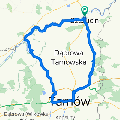
A cycling route starting in Szczucin, Lesser Poland Voivodeship, Poland.
Overview
About this route
- -:--
- Duration
- 56.4 km
- Distance
- 13 m
- Ascent
- 4 m
- Descent
- ---
- Avg. speed
- ---
- Max. altitude
Route quality
Waytypes & surfaces along the route
Waytypes
Cycleway
42.3 km
(75 %)
Road
8.5 km
(15 %)
Surfaces
Paved
53.6 km
(95 %)
Asphalt
53.6 km
(95 %)
Undefined
2.8 km
(5 %)
Route highlights
Points of interest along the route
Point of interest after 9.6 km
Kościół sklep
Point of interest after 12.2 km
Shelter/Sklep
Point of interest after 16.8 km
MOR Pawłów
Point of interest after 18.6 km
Ranczo Kanna
Point of interest after 20.9 km
Kościół
Point of interest after 23.4 km
Kościół
Point of interest after 32.8 km
MOR Ujście Jezuickie
Point of interest after 40.3 km
Shelter/Sklep
Point of interest after 49.9 km
Sklep
Point of interest after 54.3 km
Sklep
Point of interest after 56 km
MOR Kopacze Wielkie
Continue with Bikemap
Use, edit, or download this cycling route
You would like to ride Kalwaria_D1 or customize it for your own trip? Here is what you can do with this Bikemap route:
Free features
- Save this route as favorite or in collections
- Copy & plan your own version of this route
- Sync your route with Garmin or Wahoo
Premium features
Free trial for 3 days, or one-time payment. More about Bikemap Premium.
- Navigate this route on iOS & Android
- Export a GPX / KML file of this route
- Create your custom printout (try it for free)
- Download this route for offline navigation
Discover more Premium features.
Get Bikemap PremiumFrom our community
Other popular routes starting in Szczucin
 Rowerem nad morze
- Distance
- 603.5 km
- Ascent
- 547 m
- Descent
- 711 m
- Location
- Szczucin, Lesser Poland Voivodeship, Poland
 dzień 2 - Szczucin-Wiślica-Opatowiec
- Distance
- 85.1 km
- Ascent
- 69 m
- Descent
- 68 m
- Location
- Szczucin, Lesser Poland Voivodeship, Poland
 Dzień 1_Szczucin-Zalipie-Pacanów
- Distance
- 83.9 km
- Ascent
- 77 m
- Descent
- 79 m
- Location
- Szczucin, Lesser Poland Voivodeship, Poland
 Szczucin - WTR 2023
- Distance
- 50.6 km
- Ascent
- 52 m
- Descent
- 53 m
- Location
- Szczucin, Lesser Poland Voivodeship, Poland
 OS Rataje Słupskie Ciszyca Górna
- Distance
- 132.9 km
- Ascent
- 171 m
- Descent
- 198 m
- Location
- Szczucin, Lesser Poland Voivodeship, Poland
 Etap II Zawiercie Przemysl
- Distance
- 163 km
- Ascent
- 405 m
- Descent
- 373 m
- Location
- Szczucin, Lesser Poland Voivodeship, Poland
 Kraków-Szczucin
- Distance
- 127.5 km
- Ascent
- 109 m
- Descent
- 20 m
- Location
- Szczucin, Lesser Poland Voivodeship, Poland
 pętla tarnowska
- Distance
- 117.8 km
- Ascent
- 114 m
- Descent
- 112 m
- Location
- Szczucin, Lesser Poland Voivodeship, Poland
Open it in the app