
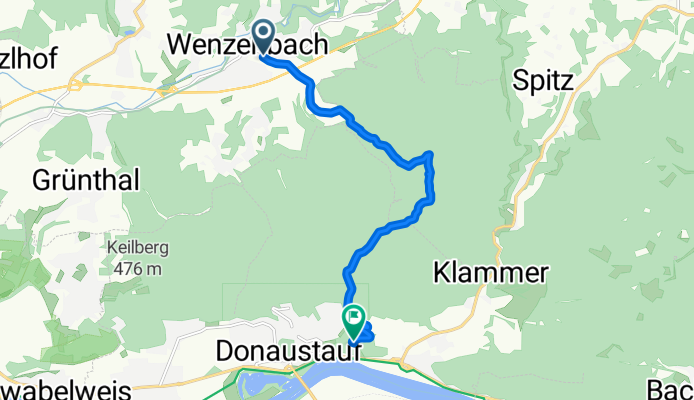
Wenzenbach -> Walhalla
A cycling route starting in Wenzenbach, Bavaria, Germany.
Overview
About this route
- -:--
- Duration
- 8.9 km
- Distance
- 220 m
- Ascent
- 173 m
- Descent
- ---
- Avg. speed
- ---
- Max. altitude

Route photos

Route quality
Waytypes & surfaces along the route
Waytypes
Track
5 km
(56 %)
Quiet road
3.3 km
(38 %)
Surfaces
Paved
1.7 km
(19 %)
Unpaved
5.1 km
(58 %)
Gravel
4.5 km
(50 %)
Asphalt
1.7 km
(19 %)
Continue with Bikemap
Use, edit, or download this cycling route
You would like to ride Wenzenbach -> Walhalla or customize it for your own trip? Here is what you can do with this Bikemap route:
Free features
- Save this route as favorite or in collections
- Copy & plan your own version of this route
- Sync your route with Garmin or Wahoo
Premium features
Free trial for 3 days, or one-time payment. More about Bikemap Premium.
- Navigate this route on iOS & Android
- Export a GPX / KML file of this route
- Create your custom printout (try it for free)
- Download this route for offline navigation
Discover more Premium features.
Get Bikemap PremiumFrom our community
Other popular routes starting in Wenzenbach
 Forstacker_Bernhardswald
- Distance
- 13.4 km
- Ascent
- 109 m
- Descent
- 222 m
- Location
- Wenzenbach, Bavaria, Germany
 Kapellenweg
- Distance
- 31.9 km
- Ascent
- 332 m
- Descent
- 332 m
- Location
- Wenzenbach, Bavaria, Germany
 WENZENBACH - TOUR
- Distance
- 39.6 km
- Ascent
- 323 m
- Descent
- 324 m
- Location
- Wenzenbach, Bavaria, Germany
 kurze-tour-trail-Spielplatz-Regenstauf.gpx
- Distance
- 20.5 km
- Ascent
- 235 m
- Descent
- 226 m
- Location
- Wenzenbach, Bavaria, Germany
 Jugenberg
- Distance
- 39.8 km
- Ascent
- 497 m
- Descent
- 496 m
- Location
- Wenzenbach, Bavaria, Germany
 Wenzenbach Kapellenweg nach Kapellenweg 20, Wenzenbach
- Distance
- 22.2 km
- Ascent
- 198 m
- Descent
- 210 m
- Location
- Wenzenbach, Bavaria, Germany
 Wenzenbach - Winzerer Höhen - Jurasteig
- Distance
- 79 km
- Ascent
- 551 m
- Descent
- 550 m
- Location
- Wenzenbach, Bavaria, Germany
 Hi u. Zruck
- Distance
- 20.9 km
- Ascent
- 380 m
- Descent
- 383 m
- Location
- Wenzenbach, Bavaria, Germany
Open it in the app