

Wandertag Grunewald hin
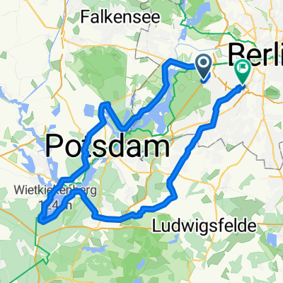
A cycling route starting in Grunewald, State of Berlin, Germany.
Overview
About this route
- 38 min
- Duration
- 6.3 km
- Distance
- 0 m
- Ascent
- 0 m
- Descent
- 10.1 km/h
- Avg. speed
- ---
- Max. altitude

Continue with Bikemap
Use, edit, or download this cycling route
You would like to ride Wandertag Grunewald hin or customize it for your own trip? Here is what you can do with this Bikemap route:
Free features
- Save this route as favorite or in collections
- Copy & plan your own version of this route
- Sync your route with Garmin or Wahoo
Premium features
Free trial for 3 days, or one-time payment. More about Bikemap Premium.
- Navigate this route on iOS & Android
- Export a GPX / KML file of this route
- Create your custom printout (try it for free)
- Download this route for offline navigation
Discover more Premium features.
Get Bikemap PremiumFrom our community
Other popular routes starting in Grunewald
 Drei Berge bei Potsdam
- Distance
- 82.4 km
- Ascent
- 305 m
- Descent
- 309 m
- Location
- Grunewald, State of Berlin, Germany
 Große Potsdamer Runde
- Distance
- 91.1 km
- Ascent
- 251 m
- Descent
- 254 m
- Location
- Grunewald, State of Berlin, Germany
 perm Wildenbruch
- Distance
- 77.1 km
- Ascent
- 230 m
- Descent
- 229 m
- Location
- Grunewald, State of Berlin, Germany
 Havelrunde
- Distance
- 57.8 km
- Ascent
- 399 m
- Descent
- 395 m
- Location
- Grunewald, State of Berlin, Germany
 Schwielowsee-Feierabendrunde finalisiert
- Distance
- 89.9 km
- Ascent
- 303 m
- Descent
- 303 m
- Location
- Grunewald, State of Berlin, Germany
 Spandau, Sacrow, Schwielowsee, Caputh, Schenkenhorst
- Distance
- 94.7 km
- Ascent
- 390 m
- Descent
- 395 m
- Location
- Grunewald, State of Berlin, Germany
 Hügelrunde über Babelsberg
- Distance
- 66.2 km
- Ascent
- 535 m
- Descent
- 518 m
- Location
- Grunewald, State of Berlin, Germany
 RTF Havel-Frühlingsrunde 2 Pkt.
- Distance
- 80.2 km
- Ascent
- 373 m
- Descent
- 378 m
- Location
- Grunewald, State of Berlin, Germany
Open it in the app