

Boucle Goëlo - 27 Août 19 - Y et L.
A cycling route starting in Lézardrieux, Brittany Region, France.
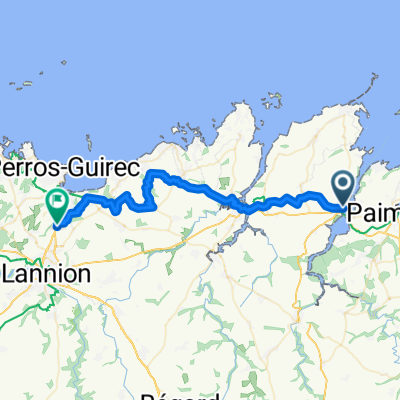
Overview
About this route
Lézardrieux (Kermenguy - Port - Town) - Pleudaniel - La Roche-Jagu - Pontrieux - St Clet - St Gilles les Bois - Pommerit le Vicomte - Paradis (chapel) - Le Merzer - St Guignan - Plouagat - Chatelaudren - Plélo - La Corderie - N.D. de la Cour - La Ville Jacob - Etables - N.D. de l’Espérance - St Quay-Portrieux (Moulin de St Michel) - Plouha - Lanloup - Plouézec - Ste Barbe - Kérity - Paimpol (Port - Kerraoul) - Lézardrieux (Bridge - Town - Port - Kermenguy).
- -:--
- Duration
- 99.4 km
- Distance
- 475 m
- Ascent
- 477 m
- Descent
- ---
- Avg. speed
- ---
- Max. altitude

Route quality
Waytypes & surfaces along the route
Waytypes
Road
23.8 km
(24 %)
Quiet road
11.9 km
(12 %)
Surfaces
Paved
60.6 km
(61 %)
Asphalt
60.6 km
(61 %)
Undefined
38.8 km
(39 %)
Continue with Bikemap
Use, edit, or download this cycling route
You would like to ride Boucle Goëlo - 27 Août 19 - Y et L. or customize it for your own trip? Here is what you can do with this Bikemap route:
Free features
- Save this route as favorite or in collections
- Copy & plan your own version of this route
- Split it into stages to create a multi-day tour
- Sync your route with Garmin or Wahoo
Premium features
Free trial for 3 days, or one-time payment. More about Bikemap Premium.
- Navigate this route on iOS & Android
- Export a GPX / KML file of this route
- Create your custom printout (try it for free)
- Download this route for offline navigation
Discover more Premium features.
Get Bikemap PremiumFrom our community
Other popular routes starting in Lézardrieux
 Lz - Bégard - Plouézec - Lz - 10 Sept. 17
- Distance
- 95.4 km
- Ascent
- 515 m
- Descent
- 514 m
- Location
- Lézardrieux, Brittany Region, France
 Boucle Goëlo - 27 Août 19 - Y et L.
- Distance
- 99.4 km
- Ascent
- 475 m
- Descent
- 477 m
- Location
- Lézardrieux, Brittany Region, France
 Lz - Concarneau ( BPF 29 ) - Lz - 11-13 Sept. 16
- Distance
- 555 km
- Ascent
- 933 m
- Descent
- 933 m
- Location
- Lézardrieux, Brittany Region, France
 Rue Saint-Christophe nach Route de Perros
- Distance
- 38.1 km
- Ascent
- 332 m
- Descent
- 280 m
- Location
- Lézardrieux, Brittany Region, France
 Lz - Morbihan - Lz ( BPF 56 )
- Distance
- 495.2 km
- Ascent
- 942 m
- Descent
- 942 m
- Location
- Lézardrieux, Brittany Region, France
 BRB 300 - Brevet Randonneurs Bretons
- Distance
- 305.5 km
- Ascent
- 1,199 m
- Descent
- 1,198 m
- Location
- Lézardrieux, Brittany Region, France
 Bréhec - Ménez-Bré - Plouaret - 22 Juillet 20.
- Distance
- 134.6 km
- Ascent
- 678 m
- Descent
- 678 m
- Location
- Lézardrieux, Brittany Region, France
 Lézardrieux - Le Légué - Guimgamp - 25 Août 18_YP.
- Distance
- 133.6 km
- Ascent
- 577 m
- Descent
- 579 m
- Location
- Lézardrieux, Brittany Region, France
Open it in the app