

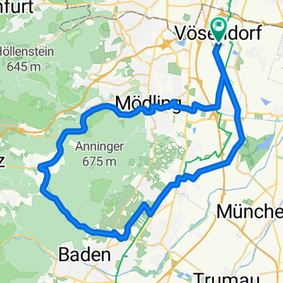
City-Donauinsel-Liesingbach Route
A cycling route starting in Vösendorf, Lower Austria, Austria.
Overview
About this route
- -:--
- Duration
- 42.7 km
- Distance
- 94 m
- Ascent
- 93 m
- Descent
- ---
- Avg. speed
- ---
- Max. altitude

Route quality
Waytypes & surfaces along the route
Waytypes
Cycleway
27.3 km
(64 %)
Quiet road
6.3 km
(15 %)
Surfaces
Paved
35 km
(82 %)
Unpaved
5.3 km
(12 %)
Asphalt
33.7 km
(79 %)
Gravel
1.9 km
(5 %)
Continue with Bikemap
Use, edit, or download this cycling route
You would like to ride City-Donauinsel-Liesingbach Route or customize it for your own trip? Here is what you can do with this Bikemap route:
Free features
- Save this route as favorite or in collections
- Copy & plan your own version of this route
- Sync your route with Garmin or Wahoo
Premium features
Free trial for 3 days, or one-time payment. More about Bikemap Premium.
- Navigate this route on iOS & Android
- Export a GPX / KML file of this route
- Create your custom printout (try it for free)
- Download this route for offline navigation
Discover more Premium features.
Get Bikemap PremiumFrom our community
Other popular routes starting in Vösendorf
 Radrunde durch Wien
- Distance
- 10.9 km
- Ascent
- 129 m
- Descent
- 36 m
- Location
- Vösendorf, Lower Austria, Austria
 Laxenburg
- Distance
- 15.6 km
- Ascent
- 37 m
- Descent
- 61 m
- Location
- Vösendorf, Lower Austria, Austria
 Wien110K
- Distance
- 109.1 km
- Ascent
- 1,407 m
- Descent
- 1,402 m
- Location
- Vösendorf, Lower Austria, Austria
 Um den Anninger
- Distance
- 42.5 km
- Ascent
- 347 m
- Descent
- 351 m
- Location
- Vösendorf, Lower Austria, Austria
 Alterlaa - Kahlenberg - Alterlaa
- Distance
- 47.2 km
- Ascent
- 705 m
- Descent
- 708 m
- Location
- Vösendorf, Lower Austria, Austria
 Liesing - Pappelteichstrecke - Liesing
- Distance
- 32.6 km
- Ascent
- 533 m
- Descent
- 536 m
- Location
- Vösendorf, Lower Austria, Austria
 St.Corona am Schöpfel und retour
- Distance
- 108.1 km
- Ascent
- 1,208 m
- Descent
- 1,206 m
- Location
- Vösendorf, Lower Austria, Austria
 Roter Ofen Umweg
- Distance
- 46.2 km
- Ascent
- 403 m
- Descent
- 402 m
- Location
- Vösendorf, Lower Austria, Austria
Open it in the app