Thonen to GVA
A cycling route starting in Messery, Auvergne-Rh么ne-Alpes, France.
Overview
About this route
- -:--
- Duration
- 27.4 km
- Distance
- 155 m
- Ascent
- 135 m
- Descent
- ---
- Avg. speed
- ---
- Avg. speed
Route quality
Waytypes & surfaces along the route
Waytypes
Quiet road
10 km
(36 %)
Busy road
6 km
(22 %)
Surfaces
Paved
22 km
(80 %)
Asphalt
22 km
(80 %)
Undefined
5.4 km
(20 %)
Continue with Bikemap
Use, edit, or download this cycling route
You would like to ride Thonen to GVA or customize it for your own trip? Here is what you can do with this Bikemap route:
Free features
- Save this route as favorite or in collections
- Copy & plan your own version of this route
- Sync your route with Garmin or Wahoo
Premium features
Free trial for 3 days, or one-time payment. More about Bikemap Premium.
- Navigate this route on iOS & Android
- Export a GPX / KML file of this route
- Create your custom printout (try it for free)
- Download this route for offline navigation
Discover more Premium features.
Get Bikemap PremiumFrom our community
Other popular routes starting in Messery
- Alpine Tour: Complete updated route
- Distance
- 588.9 km
- Ascent
- 5,870 m
- Descent
- 5,837 m
- Location
- Messery, Auvergne-Rh么ne-Alpes, France
- GenferSee(F) - LacAnnecy - LacBourget
- Distance
- 140.6 km
- Ascent
- 1,412 m
- Descent
- 1,559 m
- Location
- Messery, Auvergne-Rh么ne-Alpes, France
- Nernier - Ballaison - Col de Saxel - Arb猫re Poche- Col du Feu- Port de Sechex - Nernier
- Distance
- 83.6 km
- Ascent
- 1,532 m
- Descent
- 1,537 m
- Location
- Messery, Auvergne-Rh么ne-Alpes, France
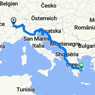
- haute route alps juli 2015 ch/u
- Distance
- 728.6 km
- Ascent
- 13,408 m
- Descent
- 13,771 m
- Location
- Messery, Auvergne-Rh么ne-Alpes, France
- Elvetia-Franta 2010. Ziua 10
- Distance
- 20.9 km
- Ascent
- 131 m
- Descent
- 148 m
- Location
- Messery, Auvergne-Rh么ne-Alpes, France
- haute-route-aps 2015 ch/u
- Distance
- 732.5 km
- Ascent
- 13,954 m
- Descent
- 14,326 m
- Location
- Messery, Auvergne-Rh么ne-Alpes, France
- Ballaison-Moises-S茅chex
- Distance
- 63.6 km
- Ascent
- 1,144 m
- Descent
- 1,148 m
- Location
- Messery, Auvergne-Rh么ne-Alpes, France
- (05) Messery - Morzine
- Distance
- 92.6 km
- Ascent
- 1,461 m
- Descent
- 969 m
- Location
- Messery, Auvergne-Rh么ne-Alpes, France
Open it in the app