09 Valepp - Erzherzog Johann Klause - Kreuth
A cycling route starting in Rottach-Egern, Bavaria, Germany.
Overview
About this route
Start zwischen Haslau und Enterrottach an einem weniger überlaufenen Wanderparkplatz. Über die Moni Alm auf der geteerten Mautstraße zum Forsthaus Valepp . Weiter zur Erzherzog–Johann-Klause (Schotter) . Zurück über die Bayernalm nach Kreuth und dem Radweg folgend zum Parkplatz. Abgesehen von einer kurzen Schiebe- oder Tragepassage bei km 25 ist alles gut fahrbar
- -:--
- Duration
- 46.7 km
- Distance
- 792 m
- Ascent
- 790 m
- Descent
- ---
- Avg. speed
- ---
- Avg. speed
Continue with Bikemap
Use, edit, or download this cycling route
You would like to ride 09 Valepp - Erzherzog Johann Klause - Kreuth or customize it for your own trip? Here is what you can do with this Bikemap route:
Free features
- Save this route as favorite or in collections
- Copy & plan your own version of this route
- Sync your route with Garmin or Wahoo
Premium features
Free trial for 3 days, or one-time payment. More about Bikemap Premium.
- Navigate this route on iOS & Android
- Export a GPX / KML file of this route
- Create your custom printout (try it for free)
- Download this route for offline navigation
Discover more Premium features.
Get Bikemap PremiumFrom our community
Other popular routes starting in Rottach-Egern
- Tegernsee, Spitzingsee
- Distance
- 31.5 km
- Ascent
- 815 m
- Descent
- 815 m
- Location
- Rottach-Egern, Bavaria, Germany
- Gotzing Taubenberg Holz
- Distance
- 64.1 km
- Ascent
- 594 m
- Descent
- 585 m
- Location
- Rottach-Egern, Bavaria, Germany
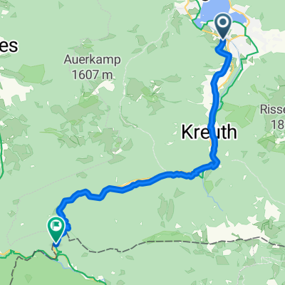
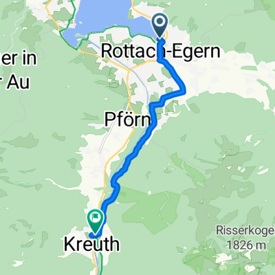
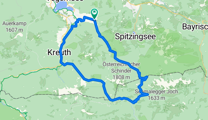
- Ringberg-MoniAlm-Valepp-Spitzingsee-Schliersee-Ringberg
- Distance
- 56.6 km
- Ascent
- 834 m
- Descent
- 834 m
- Location
- Rottach-Egern, Bavaria, Germany
- Niklasreut - Spitzingsattel - Valepp
- Distance
- 70.9 km
- Ascent
- 1,047 m
- Descent
- 844 m
- Location
- Rottach-Egern, Bavaria, Germany
- Schinder Umrundung
- Distance
- 45 km
- Ascent
- 809 m
- Descent
- 807 m
- Location
- Rottach-Egern, Bavaria, Germany
- Auernalm, Tegernsee, Rottach-Egern
- Distance
- 35.1 km
- Ascent
- 737 m
- Descent
- 735 m
- Location
- Rottach-Egern, Bavaria, Germany
- Tegernsee nach Venecia
- Distance
- 525.6 km
- Ascent
- 1,360 m
- Descent
- 2,094 m
- Location
- Rottach-Egern, Bavaria, Germany
- Pfingstrunde
- Distance
- 55.2 km
- Ascent
- 796 m
- Descent
- 798 m
- Location
- Rottach-Egern, Bavaria, Germany
Open it in the app