
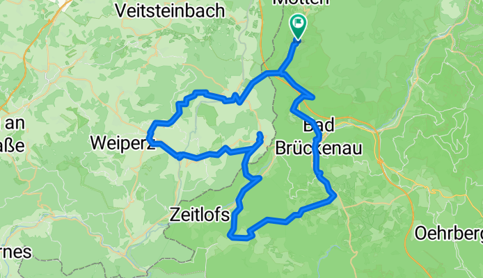
radvierer kothen 2
A cycling route starting in Motten, Bavaria, Germany.
Overview
About this route
- -:--
- Duration
- 63 km
- Distance
- 868 m
- Ascent
- 871 m
- Descent
- ---
- Avg. speed
- ---
- Max. altitude
Route quality
Waytypes & surfaces along the route
Waytypes
Quiet road
15.1 km
(24 %)
Track
14.5 km
(23 %)
Surfaces
Paved
29.6 km
(47 %)
Unpaved
12.6 km
(20 %)
Asphalt
29 km
(46 %)
Gravel
10.1 km
(16 %)
Continue with Bikemap
Use, edit, or download this cycling route
You would like to ride radvierer kothen 2 or customize it for your own trip? Here is what you can do with this Bikemap route:
Free features
- Save this route as favorite or in collections
- Copy & plan your own version of this route
- Sync your route with Garmin or Wahoo
Premium features
Free trial for 3 days, or one-time payment. More about Bikemap Premium.
- Navigate this route on iOS & Android
- Export a GPX / KML file of this route
- Create your custom printout (try it for free)
- Download this route for offline navigation
Discover more Premium features.
Get Bikemap PremiumFrom our community
Other popular routes starting in Motten
 Erste Tour 2021
- Distance
- 49.5 km
- Ascent
- 916 m
- Descent
- 917 m
- Location
- Motten, Bavaria, Germany
 Motten - Zeitlofs
- Distance
- 19.4 km
- Ascent
- 248 m
- Descent
- 287 m
- Location
- Motten, Bavaria, Germany
 zur Sinn
- Distance
- 33.9 km
- Ascent
- 436 m
- Descent
- 553 m
- Location
- Motten, Bavaria, Germany
 VM-Route im Rhön/Sinn/Saale
- Distance
- 219.4 km
- Ascent
- 785 m
- Descent
- 785 m
- Location
- Motten, Bavaria, Germany
 Vechelde - München 4. Etappe
- Distance
- 94.2 km
- Ascent
- 470 m
- Descent
- 713 m
- Location
- Motten, Bavaria, Germany
 radvierer kothen 2
- Distance
- 63 km
- Ascent
- 868 m
- Descent
- 871 m
- Location
- Motten, Bavaria, Germany
 Schmalnau-Gersfeld-Wasserkuppe
- Distance
- 39.6 km
- Ascent
- 564 m
- Descent
- 561 m
- Location
- Motten, Bavaria, Germany
 Schmalnau-Dalherda-Oberwildflecken-Kreuzberg-Bischofsheim-Gersfeld
- Distance
- 60.5 km
- Ascent
- 1,285 m
- Descent
- 1,286 m
- Location
- Motten, Bavaria, Germany
Open it in the app