

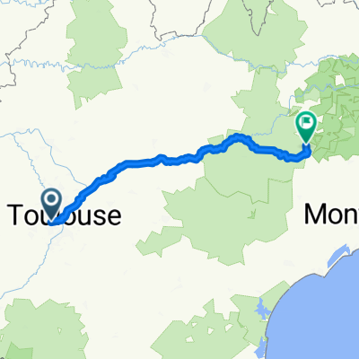
pujaudran
A cycling route starting in Tournefeuille, Occitanie, France.
Overview
About this route
- -:--
- Duration
- 56.1 km
- Distance
- 326 m
- Ascent
- 327 m
- Descent
- ---
- Avg. speed
- ---
- Max. altitude
Route quality
Waytypes & surfaces along the route
Waytypes
Road
26.9 km
(48 %)
Quiet road
20.8 km
(37 %)
Surfaces
Paved
29.7 km
(53 %)
Asphalt
28 km
(50 %)
Concrete
1.7 km
(3 %)
Undefined
26.4 km
(47 %)
Continue with Bikemap
Use, edit, or download this cycling route
You would like to ride pujaudran or customize it for your own trip? Here is what you can do with this Bikemap route:
Free features
- Save this route as favorite or in collections
- Copy & plan your own version of this route
- Sync your route with Garmin or Wahoo
Premium features
Free trial for 3 days, or one-time payment. More about Bikemap Premium.
- Navigate this route on iOS & Android
- Export a GPX / KML file of this route
- Create your custom printout (try it for free)
- Download this route for offline navigation
Discover more Premium features.
Get Bikemap PremiumFrom our community
Other popular routes starting in Tournefeuille
 Itinéraire confortable en Toulouse
- Distance
- 53.9 km
- Ascent
- 330 m
- Descent
- 330 m
- Location
- Tournefeuille, Occitanie, France
 De Rue de la Durance 15, Tournefeuille à Rue de la Durance 5, Tournefeuille
- Distance
- 43.3 km
- Ascent
- 220 m
- Descent
- 267 m
- Location
- Tournefeuille, Occitanie, France
 30 premiers km occitaman
- Distance
- 29.9 km
- Ascent
- 203 m
- Descent
- 48 m
- Location
- Tournefeuille, Occitanie, France
 Toulouse - St-Jean du Bruel
- Distance
- 237.2 km
- Ascent
- 1,459 m
- Descent
- 1,094 m
- Location
- Tournefeuille, Occitanie, France
 Toulouse - Muret / Vallée de la Garonne
- Distance
- 69.5 km
- Ascent
- 180 m
- Descent
- 178 m
- Location
- Tournefeuille, Occitanie, France
 19/07 route
- Distance
- 48.4 km
- Ascent
- 216 m
- Descent
- 219 m
- Location
- Tournefeuille, Occitanie, France
 18 Allée de l'Estérel, Colomiers to Route de Pibrac, Colomiers
- Distance
- 3.4 km
- Ascent
- 13 m
- Descent
- 20 m
- Location
- Tournefeuille, Occitanie, France
 circuit triathlon La Ramée
- Distance
- 6.9 km
- Ascent
- 56 m
- Descent
- 56 m
- Location
- Tournefeuille, Occitanie, France
Open it in the app