
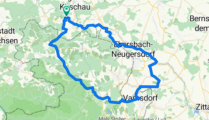
Seifhennersdorf Finkenberg
A cycling route starting in Schirgiswalde, Saxony, Germany.
Overview
About this route
May 9, 2010
- -:--
- Duration
- 74.1 km
- Distance
- 701 m
- Ascent
- 699 m
- Descent
- ---
- Avg. speed
- ---
- Max. altitude

Route quality
Waytypes & surfaces along the route
Waytypes
Quiet road
24.4 km
(33 %)
Road
6.7 km
(9 %)
Surfaces
Paved
34.8 km
(47 %)
Asphalt
34.8 km
(47 %)
Undefined
39.3 km
(53 %)
Continue with Bikemap
Use, edit, or download this cycling route
You would like to ride Seifhennersdorf Finkenberg or customize it for your own trip? Here is what you can do with this Bikemap route:
Free features
- Save this route as favorite or in collections
- Copy & plan your own version of this route
- Sync your route with Garmin or Wahoo
Premium features
Free trial for 3 days, or one-time payment. More about Bikemap Premium.
- Navigate this route on iOS & Android
- Export a GPX / KML file of this route
- Create your custom printout (try it for free)
- Download this route for offline navigation
Discover more Premium features.
Get Bikemap PremiumFrom our community
Other popular routes starting in Schirgiswalde
 kleine Tour um den Hohberg in Schirgiswalde
- Distance
- 4.8 km
- Ascent
- 128 m
- Descent
- 131 m
- Location
- Schirgiswalde, Saxony, Germany
 Mit dem Fahrrad von Schirgiswalde nach Bautzen
- Distance
- 17.1 km
- Ascent
- 146 m
- Descent
- 317 m
- Location
- Schirgiswalde, Saxony, Germany
 Schönbach b. Cunewalde
- Distance
- 57 km
- Ascent
- 583 m
- Descent
- 583 m
- Location
- Schirgiswalde, Saxony, Germany
 Bautzen zur Kreckwitzer Höhe
- Distance
- 99.4 km
- Ascent
- 747 m
- Descent
- 747 m
- Location
- Schirgiswalde, Saxony, Germany
 Bahnradweg Cunewalde
- Distance
- 51.3 km
- Ascent
- 375 m
- Descent
- 367 m
- Location
- Schirgiswalde, Saxony, Germany
 Um den Valtenberg
- Distance
- 50.5 km
- Ascent
- 436 m
- Descent
- 436 m
- Location
- Schirgiswalde, Saxony, Germany
 Sohland Karlstal Zeidler
- Distance
- 19 km
- Ascent
- 298 m
- Descent
- 171 m
- Location
- Schirgiswalde, Saxony, Germany
 Tanzplan
- Distance
- 40.3 km
- Ascent
- 464 m
- Descent
- 459 m
- Location
- Schirgiswalde, Saxony, Germany
Open it in the app