
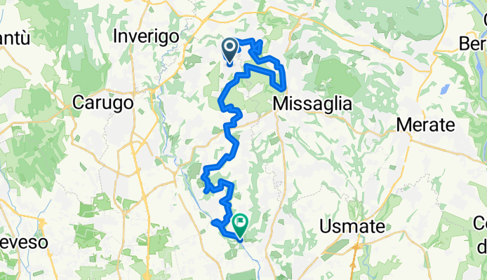
LaBrianzaInMTB-ParcoValletta-ValleLambro
A cycling route starting in Renate, Lombardy, Italy.
Overview
About this route
- -:--
- Duration
- 30 km
- Distance
- 458 m
- Ascent
- 768 m
- Descent
- ---
- Avg. speed
- ---
- Max. altitude

Route quality
Waytypes & surfaces along the route
Waytypes
Track
12 km
(40 %)
Quiet road
11.7 km
(39 %)
Surfaces
Paved
5.1 km
(17 %)
Unpaved
16.8 km
(56 %)
Ground
12.6 km
(42 %)
Asphalt
5.1 km
(17 %)
Continue with Bikemap
Use, edit, or download this cycling route
You would like to ride LaBrianzaInMTB-ParcoValletta-ValleLambro or customize it for your own trip? Here is what you can do with this Bikemap route:
Free features
- Save this route as favorite or in collections
- Copy & plan your own version of this route
- Sync your route with Garmin or Wahoo
Premium features
Free trial for 3 days, or one-time payment. More about Bikemap Premium.
- Navigate this route on iOS & Android
- Export a GPX / KML file of this route
- Create your custom printout (try it for free)
- Download this route for offline navigation
Discover more Premium features.
Get Bikemap PremiumFrom our community
Other popular routes starting in Renate
 Parco della Valletta, poi tutto attorno la collina di Montevecchia/Valle del Curone, cercando di evitare il fango
- Distance
- 43.3 km
- Ascent
- 435 m
- Descent
- 435 m
- Location
- Renate, Lombardy, Italy
 Parco della Valletta e della Valle del Curone, poi Lungo Adda Paderno - Brivio
- Distance
- 61.4 km
- Ascent
- 684 m
- Descent
- 684 m
- Location
- Renate, Lombardy, Italy
 Parco della Valletta, Sentiero dei Daini, Panoramica di Montevecchia, Strada del Sindaco, Parco dei Colli Briantei
- Distance
- 47.9 km
- Ascent
- 465 m
- Descent
- 465 m
- Location
- Renate, Lombardy, Italy
 Colle Brianza (Cologna), Monte Barro e lago di Oggiono
- Distance
- 49.1 km
- Ascent
- 787 m
- Descent
- 783 m
- Location
- Renate, Lombardy, Italy
 Attorno al lago di Montorfano
- Distance
- 61.9 km
- Ascent
- 431 m
- Descent
- 431 m
- Location
- Renate, Lombardy, Italy
 Completati tutti i track di Montevecchia e Parco del Curone
- Distance
- 44.9 km
- Ascent
- 669 m
- Descent
- 669 m
- Location
- Renate, Lombardy, Italy
 Roggia Nava (Colli Briantei), Sentiero dei Vagoncini, Strada del Sindaco, Sentiero dei Sassi, Sentiero dei Proverbi, Parco della Valletta
- Distance
- 30.5 km
- Ascent
- 421 m
- Descent
- 420 m
- Location
- Renate, Lombardy, Italy
 Colli Briantei, Bosco del Chignolo, Rio Pegorino, Parco della Valletta
- Distance
- 33.9 km
- Ascent
- 325 m
- Descent
- 325 m
- Location
- Renate, Lombardy, Italy
Open it in the app