

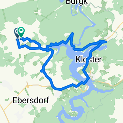
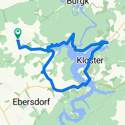
Lückenmühle - Karolinenfield - Burgk - Kobersfelsen - Staumauer - Isabellengrün - Remptendorf - Lückenmühle
A cycling route starting in Remptendorf, Thuringia, Germany.
Overview
About this route
Lückenmühle - Karolinenfield - Burgk - Kobersfelsen - Staumauer - Isabellengrün - Remptendorf - Lückenmühle
- -:--
- Duration
- 28.7 km
- Distance
- 361 m
- Ascent
- 361 m
- Descent
- ---
- Avg. speed
- ---
- Max. altitude

Continue with Bikemap
Use, edit, or download this cycling route
You would like to ride Lückenmühle - Karolinenfield - Burgk - Kobersfelsen - Staumauer - Isabellengrün - Remptendorf - Lückenmühle or customize it for your own trip? Here is what you can do with this Bikemap route:
Free features
- Save this route as favorite or in collections
- Copy & plan your own version of this route
- Sync your route with Garmin or Wahoo
Premium features
Free trial for 3 days, or one-time payment. More about Bikemap Premium.
- Navigate this route on iOS & Android
- Export a GPX / KML file of this route
- Create your custom printout (try it for free)
- Download this route for offline navigation
Discover more Premium features.
Get Bikemap PremiumFrom our community
Other popular routes starting in Remptendorf
 Route in Remptendorf
- Distance
- 25.4 km
- Ascent
- 507 m
- Descent
- 508 m
- Location
- Remptendorf, Thuringia, Germany
 Route in Remptendorf
- Distance
- 25.4 km
- Ascent
- 509 m
- Descent
- 508 m
- Location
- Remptendorf, Thuringia, Germany
 Saalesession IV
- Distance
- 20.4 km
- Ascent
- 393 m
- Descent
- 392 m
- Location
- Remptendorf, Thuringia, Germany
 Talsperre Bleiloch - Saalburg
- Distance
- 28.6 km
- Ascent
- 372 m
- Descent
- 372 m
- Location
- Remptendorf, Thuringia, Germany
 Saalesession II
- Distance
- 27.1 km
- Ascent
- 474 m
- Descent
- 473 m
- Location
- Remptendorf, Thuringia, Germany
 Röppischer Stausee-Triathlon
- Distance
- 6 km
- Ascent
- 144 m
- Descent
- 54 m
- Location
- Remptendorf, Thuringia, Germany
 Lückenmühle - Remptendorf -Ebersdorf - Saalburg - Staumauer - Isabellengrün - Lückenmühle CLONED FROM ROUTE 529081
- Distance
- 36.3 km
- Ascent
- 474 m
- Descent
- 474 m
- Location
- Remptendorf, Thuringia, Germany
 4. Tag Remptendorf - Bad Klosterlausnitz
- Distance
- 106.5 km
- Ascent
- 641 m
- Descent
- 811 m
- Location
- Remptendorf, Thuringia, Germany
Open it in the app