

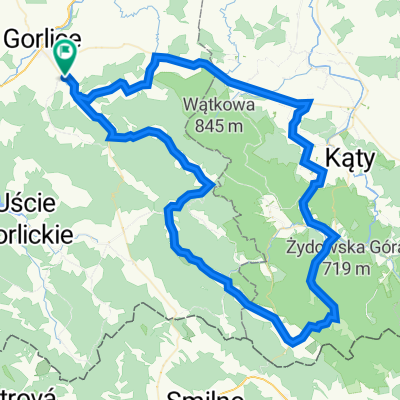
Magura pętla- 46 km
A cycling route starting in Sękowa, Lesser Poland Voivodeship, Poland.
Overview
About this route
Magura loop - 46 km
- -:--
- Duration
- 46.8 km
- Distance
- 827 m
- Ascent
- 829 m
- Descent
- ---
- Avg. speed
- ---
- Max. altitude

Route quality
Waytypes & surfaces along the route
Waytypes
Track
16.4 km
(35 %)
Quiet road
14 km
(30 %)
Surfaces
Paved
20.6 km
(44 %)
Unpaved
20.6 km
(44 %)
Asphalt
14.5 km
(31 %)
Ground
10.8 km
(23 %)
Continue with Bikemap
Use, edit, or download this cycling route
You would like to ride Magura pętla- 46 km or customize it for your own trip? Here is what you can do with this Bikemap route:
Free features
- Save this route as favorite or in collections
- Copy & plan your own version of this route
- Sync your route with Garmin or Wahoo
Premium features
Free trial for 3 days, or one-time payment. More about Bikemap Premium.
- Navigate this route on iOS & Android
- Export a GPX / KML file of this route
- Create your custom printout (try it for free)
- Download this route for offline navigation
Discover more Premium features.
Get Bikemap PremiumFrom our community
Other popular routes starting in Sękowa
 Magura pętla- 46 km
- Distance
- 46.8 km
- Ascent
- 827 m
- Descent
- 829 m
- Location
- Sękowa, Lesser Poland Voivodeship, Poland
 Magura Małostowska
- Distance
- 33.6 km
- Ascent
- 618 m
- Descent
- 617 m
- Location
- Sękowa, Lesser Poland Voivodeship, Poland
 Magura Sprint
- Distance
- 15.5 km
- Ascent
- 446 m
- Descent
- 445 m
- Location
- Sękowa, Lesser Poland Voivodeship, Poland
 Bartne
- Distance
- 58.7 km
- Ascent
- 666 m
- Descent
- 666 m
- Location
- Sękowa, Lesser Poland Voivodeship, Poland
 Jana Kochanowskiego 137, Gorlice do Jana Kochanowskiego 137, Gorlice
- Distance
- 13.1 km
- Ascent
- 155 m
- Descent
- 147 m
- Location
- Sękowa, Lesser Poland Voivodeship, Poland
 Sękowa Kolarstwo
- Distance
- 98.8 km
- Ascent
- 1,508 m
- Descent
- 1,508 m
- Location
- Sękowa, Lesser Poland Voivodeship, Poland
 Czasówka -1
- Distance
- 7.5 km
- Ascent
- 382 m
- Descent
- 46 m
- Location
- Sękowa, Lesser Poland Voivodeship, Poland
 Pętla wokół Magury Małastowskiej
- Distance
- 62.6 km
- Ascent
- 830 m
- Descent
- 832 m
- Location
- Sękowa, Lesser Poland Voivodeship, Poland
Open it in the app