2010-Tegernse, Spitzingsee, Schliersee
A cycling route starting in Rottach-Egern, Bavaria, Germany.
Overview
About this route
MTB 40% gravel 55% asphalt 5% carrying on alpine trails
- -:--
- Duration
- 74.7 km
- Distance
- 1,322 m
- Ascent
- 1,322 m
- Descent
- ---
- Avg. speed
- ---
- Max. altitude
Route highlights
Points of interest along the route
Point of interest after 29 km
Drinking water after 31.1 km
Tady se cca 1km nese. (pěšinka - krpál - kameny ...)
Continue with Bikemap
Use, edit, or download this cycling route
You would like to ride 2010-Tegernse, Spitzingsee, Schliersee or customize it for your own trip? Here is what you can do with this Bikemap route:
Free features
- Save this route as favorite or in collections
- Copy & plan your own version of this route
- Sync your route with Garmin or Wahoo
Premium features
Free trial for 3 days, or one-time payment. More about Bikemap Premium.
- Navigate this route on iOS & Android
- Export a GPX / KML file of this route
- Create your custom printout (try it for free)
- Download this route for offline navigation
Discover more Premium features.
Get Bikemap PremiumFrom our community
Other popular routes starting in Rottach-Egern
Große Tegernsee Südrunde- Distance
- 70.8 km
- Ascent
- 1,874 m
- Descent
- 1,873 m
- Location
- Rottach-Egern, Bavaria, Germany
Niklasreut - Spitzingsattel - Valepp- Distance
- 70.9 km
- Ascent
- 1,047 m
- Descent
- 844 m
- Location
- Rottach-Egern, Bavaria, Germany
Ringberg-MoniAlm-Valepp-Spitzingsee-Schliersee-Ringberg- Distance
- 56.6 km
- Ascent
- 834 m
- Descent
- 834 m
- Location
- Rottach-Egern, Bavaria, Germany
Tegernsee nach Venecia- Distance
- 525.6 km
- Ascent
- 1,360 m
- Descent
- 2,094 m
- Location
- Rottach-Egern, Bavaria, Germany
Gotzing Taubenberg Holz- Distance
- 64.1 km
- Ascent
- 594 m
- Descent
- 585 m
- Location
- Rottach-Egern, Bavaria, Germany
2010-Tegernse, Spitzingsee, Schliersee- Distance
- 74.7 km
- Ascent
- 1,322 m
- Descent
- 1,322 m
- Location
- Rottach-Egern, Bavaria, Germany
MTB Festival Tegernseer Tal Strecke B- Distance
- 55.1 km
- Ascent
- 1,633 m
- Descent
- 1,599 m
- Location
- Rottach-Egern, Bavaria, Germany
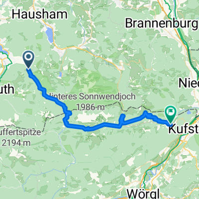
Tegernsee, Spitzingsee- Distance
- 31.5 km
- Ascent
- 815 m
- Descent
- 815 m
- Location
- Rottach-Egern, Bavaria, Germany
Open it in the app


