

Rund um Sulgen
A cycling route starting in Hardt, Baden-Wurttemberg, Germany.
Overview
About this route
Startpunkt Parkplatz Arthur Bantle Halle. Radwege oder Straßen mit wenig Verkehr. Einkehrmöglichkeiten: "Hutneck" "Waldeslust" "Hefterwaldstüble" "Vier Häuser" "Paradies"
- -:--
- Duration
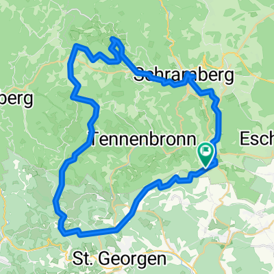
- 24.6 km
- Distance
- 253 m
- Ascent
- 265 m
- Descent
- ---
- Avg. speed
- 786 m
- Max. altitude
Route quality
Waytypes & surfaces along the route
Waytypes
Quiet road
12.8 km
(52 %)
Path
5.3 km
(22 %)
Surfaces
Paved
17.3 km
(70 %)
Unpaved
0.8 km
(3 %)
Asphalt
16.9 km
(69 %)
Gravel
0.5 km
(2 %)
Continue with Bikemap
Use, edit, or download this cycling route
You would like to ride Rund um Sulgen or customize it for your own trip? Here is what you can do with this Bikemap route:
Free features
- Save this route as favorite or in collections
- Copy & plan your own version of this route
- Sync your route with Garmin or Wahoo
Premium features
Free trial for 3 days, or one-time payment. More about Bikemap Premium.
- Navigate this route on iOS & Android
- Export a GPX / KML file of this route
- Create your custom printout (try it for free)
- Download this route for offline navigation
Discover more Premium features.
Get Bikemap PremiumFrom our community
Other popular routes starting in Hardt
 Weilerstraße 32, Hardt nach Weilerstraße 30, Hardt
- Distance
- 33.4 km
- Ascent
- 384 m
- Descent
- 367 m
- Location
- Hardt, Baden-Wurttemberg, Germany
 Viertälerweg
- Distance
- 62.9 km
- Ascent
- 995 m
- Descent
- 995 m
- Location
- Hardt, Baden-Wurttemberg, Germany
 Tennenbronn, Fohrenbühl, Sulzbach, Lauterbach, Schramberg, Sulgen, Hardt
- Distance
- 37.4 km
- Ascent
- 965 m
- Descent
- 970 m
- Location
- Hardt, Baden-Wurttemberg, Germany
 St. Geoergen, Windkapf, Fohrenbühl, Lauterbach, Schramber, Sulgen, Mariazell, Hardt
- Distance
- 49.6 km
- Ascent
- 979 m
- Descent
- 975 m
- Location
- Hardt, Baden-Wurttemberg, Germany
 KA-ZH Teil-3 Hardt-Bonndorf
- Distance
- 58.9 km
- Ascent
- 541 m
- Descent
- 471 m
- Location
- Hardt, Baden-Wurttemberg, Germany
 Langsame Fahrt in Hardt
- Distance
- 13.6 km
- Ascent
- 296 m
- Descent
- 256 m
- Location
- Hardt, Baden-Wurttemberg, Germany
 Große Fohrenbühl Runde
- Distance
- 47.9 km
- Ascent
- 1,043 m
- Descent
- 1,042 m
- Location
- Hardt, Baden-Wurttemberg, Germany
 Rund um Sulgen
- Distance
- 24.6 km
- Ascent
- 253 m
- Descent
- 265 m
- Location
- Hardt, Baden-Wurttemberg, Germany
Open it in the app