

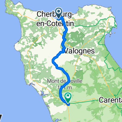
01. Cherbourg - Valognes
A cycling route starting in Cherbourg, Normandy, France.
Overview
About this route
- -:--
- Duration
- 24.5 km
- Distance
- 200 m
- Ascent
- 166 m
- Descent
- ---
- Avg. speed
- ---
- Max. altitude

Route quality
Waytypes & surfaces along the route
Waytypes
Road
18.6 km
(76 %)
Cycleway
2.2 km
(9 %)
Surfaces
Paved
21.1 km
(86 %)
Unpaved
0.5 km
(2 %)
Asphalt
21.1 km
(86 %)
Unpaved (undefined)
0.5 km
(2 %)
Undefined
2.9 km
(12 %)
Continue with Bikemap
Use, edit, or download this cycling route
You would like to ride 01. Cherbourg - Valognes or customize it for your own trip? Here is what you can do with this Bikemap route:
Free features
- Save this route as favorite or in collections
- Copy & plan your own version of this route
- Sync your route with Garmin or Wahoo
Premium features
Free trial for 3 days, or one-time payment. More about Bikemap Premium.
- Navigate this route on iOS & Android
- Export a GPX / KML file of this route
- Create your custom printout (try it for free)
- Download this route for offline navigation
Discover more Premium features.
Get Bikemap PremiumFrom our community
Other popular routes starting in Cherbourg
 From Cherbourg-en-Cotentin to La Haye
- Distance
- 59.4 km
- Ascent
- 554 m
- Descent
- 518 m
- Location
- Cherbourg, Normandy, France
 D-Day 20250606
- Distance
- 318.9 km
- Ascent
- 6,593 m
- Descent
- 6,609 m
- Location
- Cherbourg, Normandy, France
 Route to Hôtel Le Vauban
- Distance
- 72.4 km
- Ascent
- 441 m
- Descent
- 435 m
- Location
- Cherbourg, Normandy, France
 Route nach Brunssum
- Distance
- 934.2 km
- Ascent
- 4,613 m
- Descent
- 4,578 m
- Location
- Cherbourg, Normandy, France
 2025 1 Cherbourg go Bricquebec
- Distance
- 27.2 km
- Ascent
- 320 m
- Descent
- 276 m
- Location
- Cherbourg, Normandy, France
 01. Cherbourg - Valognes
- Distance
- 24.5 km
- Ascent
- 200 m
- Descent
- 166 m
- Location
- Cherbourg, Normandy, France
 Cherbourg-Octeville - barfleur
- Distance
- 34.8 km
- Ascent
- 377 m
- Descent
- 376 m
- Location
- Cherbourg, Normandy, France
 faya cotentin tour
- Distance
- 222.4 km
- Ascent
- 3,210 m
- Descent
- 3,209 m
- Location
- Cherbourg, Normandy, France
Open it in the app