

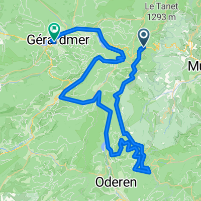
Schildmatt und Umgebung
A cycling route starting in Soultzeren, Grand Est, France.
Overview
About this route
Beautiful circular route starting at the self-catering hut 'Schildmatt' or alternatively in the Munster valley. Partly little trafficked.
- -:--
- Duration
- 57.4 km
- Distance
- 1,332 m
- Ascent
- 1,332 m
- Descent
- ---
- Avg. speed
- ---
- Max. altitude
Route quality
Waytypes & surfaces along the route
Waytypes
Road
10.9 km
(19 %)
Track
9.8 km
(17 %)
Surfaces
Paved
36.8 km
(64 %)
Unpaved
8 km
(14 %)
Asphalt
35.6 km
(62 %)
Unpaved (undefined)
6.9 km
(12 %)
Continue with Bikemap
Use, edit, or download this cycling route
You would like to ride Schildmatt und Umgebung or customize it for your own trip? Here is what you can do with this Bikemap route:
Free features
- Save this route as favorite or in collections
- Copy & plan your own version of this route
- Sync your route with Garmin or Wahoo
Premium features
Free trial for 3 days, or one-time payment. More about Bikemap Premium.
- Navigate this route on iOS & Android
- Export a GPX / KML file of this route
- Create your custom printout (try it for free)
- Download this route for offline navigation
Discover more Premium features.
Get Bikemap PremiumFrom our community
Other popular routes starting in Soultzeren
 Schildmatt und Umgebung
- Distance
- 57.4 km
- Ascent
- 1,332 m
- Descent
- 1,332 m
- Location
- Soultzeren, Grand Est, France
 Grande and Petite Ballon - moderately hard
- Distance
- 106 km
- Ascent
- 2,025 m
- Descent
- 2,027 m
- Location
- Soultzeren, Grand Est, France
 F_Vogesen-Felsenpfad-ColDeLaSchlucht_RR-6km-320hm
- Distance
- 5.9 km
- Ascent
- 454 m
- Descent
- 453 m
- Location
- Soultzeren, Grand Est, France
 Stef@ns Tour zur Tour 2005 Etappe 3 Teil 1 am 09.07.05
- Distance
- 33 km
- Ascent
- 763 m
- Descent
- 763 m
- Location
- Soultzeren, Grand Est, France
 Wettstein-Lac Forlet- Lac Noir
- Distance
- 12.9 km
- Ascent
- 537 m
- Descent
- 542 m
- Location
- Soultzeren, Grand Est, France
 Petit Ballon + Col de Platzerwasel (short)
- Distance
- 70.6 km
- Ascent
- 1,637 m
- Descent
- 1,616 m
- Location
- Soultzeren, Grand Est, France
 Col de la Schlucht<>Gerardmer
- Distance
- 78.3 km
- Ascent
- 1,042 m
- Descent
- 1,511 m
- Location
- Soultzeren, Grand Est, France
 Stef@ns Tour zur Tour 2005 Etappe 3 Teil 2 am 09.07.05
- Distance
- 64.2 km
- Ascent
- 1,383 m
- Descent
- 1,790 m
- Location
- Soultzeren, Grand Est, France
Open it in the app