
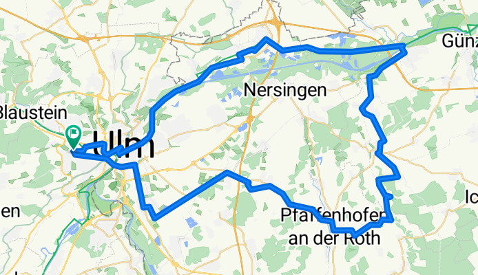
Von Söflingen ins Donautalund über Neu-Ulm zurück
A cycling route starting in Ulm, Baden-Württemberg, Germany.
Overview
About this route
Start in Söflingen, Fahrt durch Ulm, am Ulmer Münster vorbei und ins Färberviertel. An der Donau durchs Donauried bis Leipheim, dann über Nebenstrecken wieder zurück nach Ulm.
Für Verpflegung ist unterwegs an schönen "Weißwurststationen" mit Spielplätzen gesorgt.
- -:--
- Duration
- 67.5 km
- Distance
- 159 m
- Ascent
- 161 m
- Descent
- ---
- Avg. speed
- ---
- Max. altitude
Route quality
Waytypes & surfaces along the route
Waytypes
Path
15.5 km
(23 %)
Quiet road
14.5 km
(21 %)
Surfaces
Paved
54.6 km
(81 %)
Unpaved
5.1 km
(8 %)
Asphalt
52.8 km
(78 %)
Gravel
4.9 km
(7 %)
Continue with Bikemap
Use, edit, or download this cycling route
You would like to ride Von Söflingen ins Donautalund über Neu-Ulm zurück or customize it for your own trip? Here is what you can do with this Bikemap route:
Free features
- Save this route as favorite or in collections
- Copy & plan your own version of this route
- Sync your route with Garmin or Wahoo
Premium features
Free trial for 3 days, or one-time payment. More about Bikemap Premium.
- Navigate this route on iOS & Android
- Export a GPX / KML file of this route
- Create your custom printout (try it for free)
- Download this route for offline navigation
Discover more Premium features.
Get Bikemap PremiumFrom our community
Other popular routes starting in Ulm
 Ulm-Donau-Bodensee-Iller
- Distance
- 405.6 km
- Ascent
- 754 m
- Descent
- 753 m
- Location
- Ulm, Baden-Württemberg, Germany
 Ulm - Firedrichshafen (Bodensee)
- Distance
- 131.3 km
- Ascent
- 929 m
- Descent
- 969 m
- Location
- Ulm, Baden-Württemberg, Germany
 Ulm-Bodensee, Hausstrecke
- Distance
- 137.7 km
- Ascent
- 870 m
- Descent
- 868 m
- Location
- Ulm, Baden-Württemberg, Germany
 1.Etappe Ulm-Gardasee-Ulm
- Distance
- 137 km
- Ascent
- 417 m
- Descent
- 509 m
- Location
- Ulm, Baden-Württemberg, Germany
 Blaustein-Örlingen-Donau
- Distance
- 28.9 km
- Ascent
- 222 m
- Descent
- 219 m
- Location
- Ulm, Baden-Württemberg, Germany
 25 km Trainingsroute Ulm
- Distance
- 25.1 km
- Ascent
- 90 m
- Descent
- 87 m
- Location
- Ulm, Baden-Württemberg, Germany
 Hills @Blautal
- Distance
- 48.9 km
- Ascent
- 540 m
- Descent
- 540 m
- Location
- Ulm, Baden-Württemberg, Germany
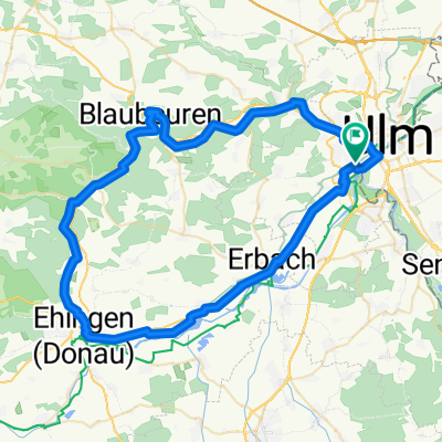 Ulm - Blaubeuren - Ehingen - Erbach - Ulm
- Distance
- 68.1 km
- Ascent
- 266 m
- Descent
- 266 m
- Location
- Ulm, Baden-Württemberg, Germany
Open it in the app