Treviglio - Sergnano _ anello 47 km
A cycling route starting in Treviglio, Lombardy, Italy.
Overview
About this route
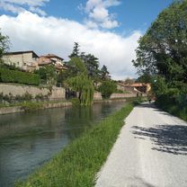
Interesting loop ride with several stretches of the route on gravel, the rest on secondary roads, bike paths, or rarely on lightly trafficked roads. Some stretches are beautiful from a naturalistic point of view, in open countryside, in the fontaniles area (Capralba area), and particularly the path area alongside the Serio River (see photo).
- 3 h 30 min
- Duration
- 47.2 km
- Distance
- 45 m
- Ascent
- 45 m
- Descent
- 13.5 km/h
- Avg. speed
- ---
- Max. altitude
Route photos
Route quality
Waytypes & surfaces along the route
Waytypes
Quiet road
14.6 km
(31 %)
Track
10.4 km
(22 %)
Surfaces
Paved
22.2 km
(47 %)
Unpaved
12.7 km
(27 %)
Asphalt
21.7 km
(46 %)
Ground
8 km
(17 %)
Continue with Bikemap
Use, edit, or download this cycling route
You would like to ride Treviglio - Sergnano _ anello 47 km or customize it for your own trip? Here is what you can do with this Bikemap route:
Free features
- Save this route as favorite or in collections
- Copy & plan your own version of this route
- Sync your route with Garmin or Wahoo
Premium features
Free trial for 3 days, or one-time payment. More about Bikemap Premium.
- Navigate this route on iOS & Android
- Export a GPX / KML file of this route
- Create your custom printout (try it for free)
- Download this route for offline navigation
Discover more Premium features.
Get Bikemap PremiumFrom our community
Other popular routes starting in Treviglio
 Day9
Day9- Distance
- 38.7 km
- Ascent
- 37 m
- Descent
- 31 m
- Location
- Treviglio, Lombardy, Italy
 Corneliano Bertario - Parco Adda Sud
- Distance
- 50.7 km
- Ascent
- 78 m
- Descent
- 76 m
- Location
- Treviglio, Lombardy, Italy
 Treviglio-Bariano Fo t.le Brancaleone anello
- Distance
- 35.7 km
- Ascent
- 34 m
- Descent
- 35 m
- Location
- Treviglio, Lombardy, Italy
 treviglio rivolta via adda e muzza
- Distance
- 32.8 km
- Ascent
- 49 m
- Descent
- 51 m
- Location
- Treviglio, Lombardy, Italy
 Giro delle "fogne" di Milano (itinerario di Giovanni)
- Distance
- 81.7 km
- Ascent
- 64 m
- Descent
- 61 m
- Location
- Treviglio, Lombardy, Italy
 Treviglio - Canonica _ anello
- Distance
- 27.3 km
- Ascent
- 409 m
- Descent
- 402 m
- Location
- Treviglio, Lombardy, Italy
 TREVIGLIO-CARAVAGGIO-S.MARIA DELLA FONTE-LODI
- Distance
- 52.9 km
- Ascent
- 62 m
- Descent
- 106 m
- Location
- Treviglio, Lombardy, Italy
 Tappa 9b - 7 agosto
- Distance
- 27.8 km
- Ascent
- 89 m
- Descent
- 25 m
- Location
- Treviglio, Lombardy, Italy
Open it in the app


