

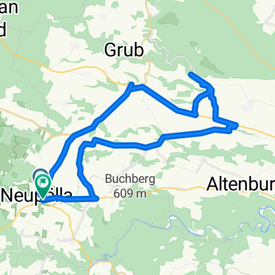
1 nap Ramsautól
A cycling route starting in Röhrenbach, Lower Austria, Austria.
Overview
About this route
1 night in Ramsau
- -:--
- Duration
- 66.3 km
- Distance
- 659 m
- Ascent
- 532 m
- Descent
- ---
- Avg. speed
- ---
- Max. altitude

Route quality
Waytypes & surfaces along the route
Waytypes
Road
35.1 km
(53 %)
Quiet road
13.9 km
(21 %)
Surfaces
Paved
22.5 km
(34 %)
Unpaved
2 km
(3 %)
Asphalt
19.2 km
(29 %)
Paved (undefined)
3.3 km
(5 %)
Continue with Bikemap
Use, edit, or download this cycling route
You would like to ride 1 nap Ramsautól or customize it for your own trip? Here is what you can do with this Bikemap route:
Free features
- Save this route as favorite or in collections
- Copy & plan your own version of this route
- Sync your route with Garmin or Wahoo
Premium features
Free trial for 3 days, or one-time payment. More about Bikemap Premium.
- Navigate this route on iOS & Android
- Export a GPX / KML file of this route
- Create your custom printout (try it for free)
- Download this route for offline navigation
Discover more Premium features.
Get Bikemap PremiumFrom our community
Other popular routes starting in Röhrenbach
 Tagesrunde Pölla
- Distance
- 38.6 km
- Ascent
- 408 m
- Descent
- 412 m
- Location
- Röhrenbach, Lower Austria, Austria
 Tautendorf bei Röhrenbach 23 nach Tautendorf bei Röhrenbach 23
- Distance
- 22.7 km
- Ascent
- 407 m
- Descent
- 459 m
- Location
- Röhrenbach, Lower Austria, Austria
 Wegscheid - Kamptal - Langenlois - Krems
- Distance
- 63.3 km
- Ascent
- 338 m
- Descent
- 514 m
- Location
- Röhrenbach, Lower Austria, Austria
 Route in Pölla
- Distance
- 35.1 km
- Ascent
- 382 m
- Descent
- 386 m
- Location
- Röhrenbach, Lower Austria, Austria
 Volt-Runde Pölla
- Distance
- 38.1 km
- Ascent
- 423 m
- Descent
- 407 m
- Location
- Röhrenbach, Lower Austria, Austria
 3Tages Tour Waldviertel
- Distance
- 195.6 km
- Ascent
- 2,727 m
- Descent
- 2,720 m
- Location
- Röhrenbach, Lower Austria, Austria
 1 nap Ramsautól
- Distance
- 66.3 km
- Ascent
- 659 m
- Descent
- 532 m
- Location
- Röhrenbach, Lower Austria, Austria
 ramsau
- Distance
- 13.3 km
- Ascent
- 148 m
- Descent
- 125 m
- Location
- Röhrenbach, Lower Austria, Austria
Open it in the app