![08.06.10 Weimar-Bad Berka-Weimar [Bilder]](/_next/static/media/contour-lines-light-small.cafd5e5d.avif)
![08.06.10 Weimar-Bad Berka-Weimar [Bilder]](https://media.bikemap.net/routes/532257/staticmaps/in_f392eacb-2c73-4e2c-ba54-64c1172ea5bf_694x400_bikemap-2021-3D-static.png)
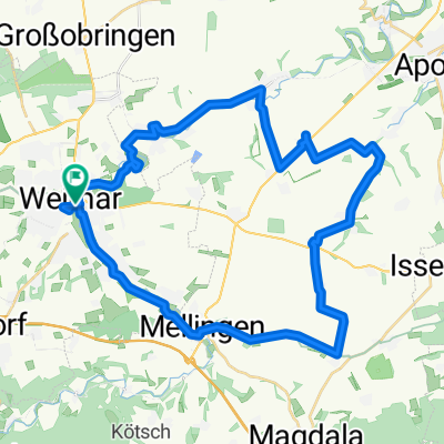
08.06.10 Weimar-Bad Berka-Weimar [Bilder]
A cycling route starting in Weimar, Thuringia, Germany.
Overview
About this route
Including the Kirschbach Valley and Hexenberg. The climb up to Hexenberg is a difficult portage section. Not for the untrained.
- -:--
- Duration
- 32 km
- Distance
- 470 m
- Ascent
- 472 m
- Descent
- ---
- Avg. speed
- ---
- Max. altitude

Route highlights
Points of interest along the route
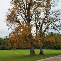
![Highlight 1 along the Bikemap route "08.06.10 Weimar-Bad Berka-Weimar [Bilder]"](https://media.bikemap.net/routes/532257/pois/ff10f7a5-c510-4790-ab19-65d1f998f5f8.jpeg "Highlight 1 along the Bikemap route \"08.06.10 Weimar-Bad Berka-Weimar [Bilder]\"")
Photo after 17.8 km
![Highlight 2 along the Bikemap route "08.06.10 Weimar-Bad Berka-Weimar [Bilder]"](https://media.bikemap.net/routes/532257/pois/8addba71-13ca-46bb-9ebd-5b8dd4958bbe.jpeg "Highlight 2 along the Bikemap route \"08.06.10 Weimar-Bad Berka-Weimar [Bilder]\"")
Photo after 19.2 km
![Highlight 3 along the Bikemap route "08.06.10 Weimar-Bad Berka-Weimar [Bilder]"](https://media.bikemap.net/routes/532257/pois/b1d8c6ce-ffc9-45c9-a92c-53f23d0b427b.jpeg "Highlight 3 along the Bikemap route \"08.06.10 Weimar-Bad Berka-Weimar [Bilder]\"")
Photo after 19.5 km
Continue with Bikemap
Use, edit, or download this cycling route
You would like to ride 08.06.10 Weimar-Bad Berka-Weimar [Bilder] or customize it for your own trip? Here is what you can do with this Bikemap route:
Free features
- Save this route as favorite or in collections
- Copy & plan your own version of this route
- Sync your route with Garmin or Wahoo
Premium features
Free trial for 3 days, or one-time payment. More about Bikemap Premium.
- Navigate this route on iOS & Android
- Export a GPX / KML file of this route
- Create your custom printout (try it for free)
- Download this route for offline navigation
Discover more Premium features.
Get Bikemap PremiumFrom our community
Other popular routes starting in Weimar
 Rundtour um Weimar
- Distance
- 41.2 km
- Ascent
- 241 m
- Descent
- 249 m
- Location
- Weimar, Thuringia, Germany
 100km Trainingsrunde in Weimars Süden
- Distance
- 99.3 km
- Ascent
- 962 m
- Descent
- 901 m
- Location
- Weimar, Thuringia, Germany
 Trainingsrunde 13/14
- Distance
- 24.8 km
- Ascent
- 253 m
- Descent
- 253 m
- Location
- Weimar, Thuringia, Germany
 Himmelfahrtausfahrt (Weimarer Löwen) 2012-05-17
- Distance
- 77.7 km
- Ascent
- 435 m
- Descent
- 435 m
- Location
- Weimar, Thuringia, Germany
![10.04.10 Ilmtal-Salle-Radwanderweg zurück über Jena [Bilder]](https://media.bikemap.net/routes/443141/staticmaps/in_0131ad86-0f8d-40e3-b0dd-ec2b4f109e5f_400x400_bikemap-2021-3D-static.png) 10.04.10 Ilmtal-Salle-Radwanderweg zurück über Jena [Bilder]
10.04.10 Ilmtal-Salle-Radwanderweg zurück über Jena [Bilder]- Distance
- 93.9 km
- Ascent
- 608 m
- Descent
- 590 m
- Location
- Weimar, Thuringia, Germany
![08.06.10 Weimar-Bad Berka-Weimar [Bilder]](https://media.bikemap.net/routes/532257/staticmaps/in_f392eacb-2c73-4e2c-ba54-64c1172ea5bf_400x400_bikemap-2021-3D-static.png) 08.06.10 Weimar-Bad Berka-Weimar [Bilder]
08.06.10 Weimar-Bad Berka-Weimar [Bilder]- Distance
- 32 km
- Ascent
- 470 m
- Descent
- 472 m
- Location
- Weimar, Thuringia, Germany
 Friedensradfahrt 2009 Paris - Moskau 15. Etappe Weimar - Bad Sulza am 20. Juli 2009
- Distance
- 29.1 km
- Ascent
- 192 m
- Descent
- 260 m
- Location
- Weimar, Thuringia, Germany
 Leibnizallee 1A nach Corona-Schröter-Weg
- Distance
- 7.3 km
- Ascent
- 81 m
- Descent
- 89 m
- Location
- Weimar, Thuringia, Germany
Open it in the app