

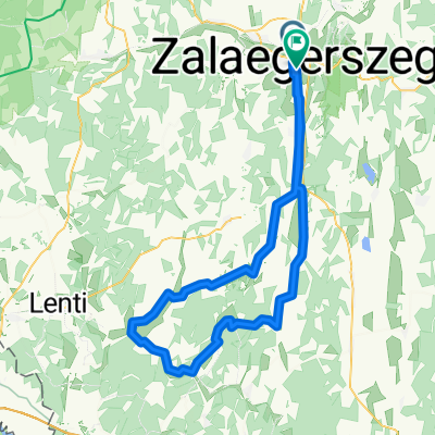
cyklotour "Okolo Jadranu a přes Alpy domů" (kod CT2009)
A cycling route starting in Zalaegerszeg, Zala County, Hungary.
Overview
About this route
- Bike tour 'Around the Adriatic and home via the Alps'
- Distance ridden: 2800 km
- Period: 10.7.-15.8.2009 (37 days)
- -:--
- Duration
- 3,001.2 km
- Distance
- 5,430 m
- Ascent
- 5,009 m
- Descent
- ---
- Avg. speed
- ---
- Max. altitude
Continue with Bikemap
Use, edit, or download this cycling route
You would like to ride cyklotour "Okolo Jadranu a přes Alpy domů" (kod CT2009) or customize it for your own trip? Here is what you can do with this Bikemap route:
Free features
- Save this route as favorite or in collections
- Copy & plan your own version of this route
- Split it into stages to create a multi-day tour
- Sync your route with Garmin or Wahoo
Premium features
Free trial for 3 days, or one-time payment. More about Bikemap Premium.
- Navigate this route on iOS & Android
- Export a GPX / KML file of this route
- Create your custom printout (try it for free)
- Download this route for offline navigation
Discover more Premium features.
Get Bikemap PremiumFrom our community
Other popular routes starting in Zalaegerszeg
 Route in Zalaegerszeg
- Distance
- 90.5 km
- Ascent
- 550 m
- Descent
- 543 m
- Location
- Zalaegerszeg, Zala County, Hungary
 Zeg- szegek- Becsvölgye- Zeg
- Distance
- 49.5 km
- Ascent
- 475 m
- Descent
- 476 m
- Location
- Zalaegerszeg, Zala County, Hungary
 Kutyakerülő technikás
- Distance
- 44.8 km
- Ascent
- 322 m
- Descent
- 308 m
- Location
- Zalaegerszeg, Zala County, Hungary
 Boncodfölde - Rákóczi utca
- Distance
- 19.4 km
- Ascent
- 143 m
- Descent
- 163 m
- Location
- Zalaegerszeg, Zala County, Hungary
 rét utca - rét utca
- Distance
- 130.3 km
- Ascent
- 604 m
- Descent
- 656 m
- Location
- Zalaegerszeg, Zala County, Hungary
 Hegyi maraton rövid táv
- Distance
- 10.4 km
- Ascent
- 213 m
- Descent
- 213 m
- Location
- Zalaegerszeg, Zala County, Hungary
 Enduro reverse - ringlóval ;)
- Distance
- 19.9 km
- Ascent
- 238 m
- Descent
- 248 m
- Location
- Zalaegerszeg, Zala County, Hungary
 Őrségi kör
- Distance
- 85.5 km
- Ascent
- 312 m
- Descent
- 312 m
- Location
- Zalaegerszeg, Zala County, Hungary
Open it in the app