

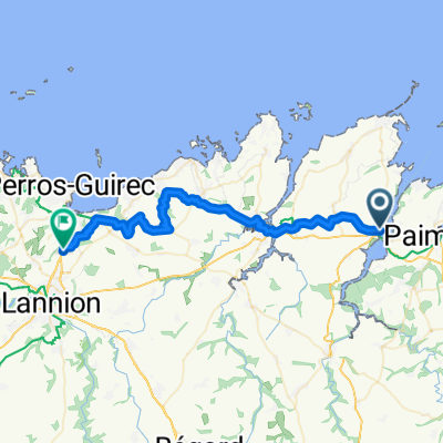
Lézardrieux - Roc'h Trédudon - Huelgoat - 18 Sept. 19.
A cycling route starting in Lézardrieux, Brittany Region, France.
Overview
About this route
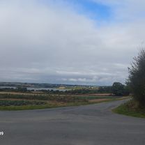
Lézardrieux - Pleumeur-Gautier - Trédarzec - Tréguiers - Lannion - St-Michel en grève - St Efflam - Plestin les grèves - Plouégat-Guérem - Plouigneau - St Eutrope - Plourin les Morlaix - CV - Quelern - Le Cloître-St Thégonnec - Quillien - Le Plessis - Abbaye du Relecq - Plounéour-Ménez - Col de Trédudon (361 m) - D36-D764 - La Feuillée - D42 - Quinoualc'h - Berrien - Huelgoat.
- -:--
- Duration
- 107.2 km
- Distance
- 729 m
- Ascent
- 561 m
- Descent
- ---
- Avg. speed
- ---
- Max. altitude

Route quality
Waytypes & surfaces along the route
Waytypes
Road
40.7 km
(38 %)
Quiet road
13.9 km
(13 %)
Surfaces
Paved
57.9 km
(54 %)
Unpaved
1.1 km
(1 %)
Asphalt
57.9 km
(54 %)
Sand
1.1 km
(1 %)
Undefined
48.2 km
(45 %)
Continue with Bikemap
Use, edit, or download this cycling route
You would like to ride Lézardrieux - Roc'h Trédudon - Huelgoat - 18 Sept. 19. or customize it for your own trip? Here is what you can do with this Bikemap route:
Free features
- Save this route as favorite or in collections
- Copy & plan your own version of this route
- Split it into stages to create a multi-day tour
- Sync your route with Garmin or Wahoo
Premium features
Free trial for 3 days, or one-time payment. More about Bikemap Premium.
- Navigate this route on iOS & Android
- Export a GPX / KML file of this route
- Create your custom printout (try it for free)
- Download this route for offline navigation
Discover more Premium features.
Get Bikemap PremiumFrom our community
Other popular routes starting in Lézardrieux
 Monts d'Arrée et du Mené - Pl-Br-Pl - 20 & 21 Août 19.
- Distance
- 588.7 km
- Ascent
- 1,636 m
- Descent
- 1,636 m
- Location
- Lézardrieux, Brittany Region, France
 Lézardrieux - Le Légué - Guimgamp - 25 Août 18_YP.
- Distance
- 133.6 km
- Ascent
- 577 m
- Descent
- 579 m
- Location
- Lézardrieux, Brittany Region, France
 Lz - Concarneau ( BPF 29 ) - Lz - 11-13 Sept. 16
- Distance
- 555 km
- Ascent
- 933 m
- Descent
- 933 m
- Location
- Lézardrieux, Brittany Region, France
 Lz - Morbihan - Lz ( BPF 56 )
- Distance
- 495.2 km
- Ascent
- 942 m
- Descent
- 942 m
- Location
- Lézardrieux, Brittany Region, France
 Boucle Goëlo - 27 Août 19 - Y et L.
- Distance
- 99.4 km
- Ascent
- 475 m
- Descent
- 477 m
- Location
- Lézardrieux, Brittany Region, France
 Chemin de Kerguistin nach Rue de Cruckin
- Distance
- 42.8 km
- Ascent
- 330 m
- Descent
- 420 m
- Location
- Lézardrieux, Brittany Region, France
 BRB 300 - Brevet Randonneurs Bretons
- Distance
- 305.5 km
- Ascent
- 1,199 m
- Descent
- 1,198 m
- Location
- Lézardrieux, Brittany Region, France
 Rue Saint-Christophe nach Route de Perros
- Distance
- 38.1 km
- Ascent
- 332 m
- Descent
- 280 m
- Location
- Lézardrieux, Brittany Region, France
Open it in the app