
tttttt
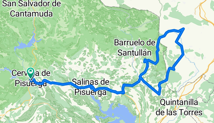
A cycling route starting in Cervera de Pisuerga, Castille and León, Spain.
Overview
About this route
dddddd
- -:--
- Duration
- 80.2 km
- Distance
- 500 m
- Ascent
- 496 m
- Descent
- ---
- Avg. speed
- ---
- Avg. speed

Route quality
Waytypes & surfaces along the route
Waytypes
Busy road
29.4 km
(37 %)
Road
28.7 km
(36 %)
Surfaces
Paved
39.1 km
(49 %)
Unpaved
2.3 km
(3 %)
Asphalt
38.7 km
(48 %)
Unpaved (undefined)
1.1 km
(1 %)
Continue with Bikemap
Use, edit, or download this cycling route
You would like to ride tttttt or customize it for your own trip? Here is what you can do with this Bikemap route:
Free features
- Save this route as favorite or in collections
- Copy & plan your own version of this route
- Split it into stages to create a multi-day tour
- Sync your route with Garmin or Wahoo
Premium features
Free trial for 3 days, or one-time payment. More about Bikemap Premium.
- Navigate this route on iOS & Android
- Export a GPX / KML file of this route
- Create your custom printout (try it for free)
- Download this route for offline navigation
Discover more Premium features.
Get Bikemap PremiumFrom our community
Other popular routes starting in Cervera de Pisuerga
 Cervera de Pisuerga - Santuario de la Virgen del Brezo
- Distance
- 130.1 km
- Ascent
- 1,483 m
- Descent
- 1,243 m
- Location
- Cervera de Pisuerga, Castille and León, Spain
 Fuente Deshondonada
- Distance
- 31.2 km
- Ascent
- 320 m
- Descent
- 320 m
- Location
- Cervera de Pisuerga, Castille and León, Spain
 Tag 4 von Cervera de Pisuera nach Mediana de Pomar
- Distance
- 112.7 km
- Ascent
- 634 m
- Descent
- 1,055 m
- Location
- Cervera de Pisuerga, Castille and León, Spain
 Ruta pantanos. Montaña palentina. Cervera-Cervera
- Distance
- 97 km
- Ascent
- 727 m
- Descent
- 708 m
- Location
- Cervera de Pisuerga, Castille and León, Spain
 Ruta de los Pantanos
- Distance
- 97.2 km
- Ascent
- 729 m
- Descent
- 729 m
- Location
- Cervera de Pisuerga, Castille and León, Spain
 cervera-vidrieros-puertos de riofrio-ledantes
- Distance
- 56.6 km
- Ascent
- 1,059 m
- Descent
- 1,262 m
- Location
- Cervera de Pisuerga, Castille and León, Spain
 Cervera de pisuerga
- Distance
- 103.7 km
- Ascent
- 1,058 m
- Descent
- 1,062 m
- Location
- Cervera de Pisuerga, Castille and León, Spain
 Valsadornin - EL GOLOBAR - Aguilar de Campoo - Valsadornin
- Distance
- 108.6 km
- Ascent
- 1,828 m
- Descent
- 1,828 m
- Location
- Cervera de Pisuerga, Castille and León, Spain
Open it in the app