

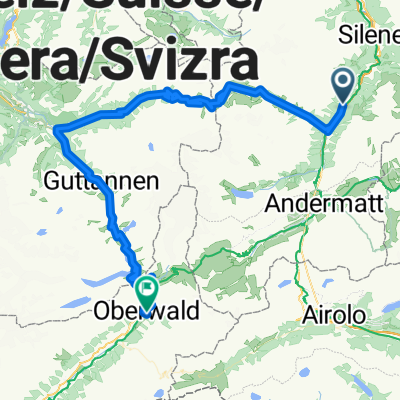
PASSO SAN GOTTARDO/ GOTTHARDPASS (por Hospental)
A cycling route starting in Silenen, Canton of Uri, Switzerland.
Overview
About this route
- -:--
- Duration
- 34.6 km
- Distance
- 1,614 m
- Ascent
- 42 m
- Descent
- ---
- Avg. speed
- ---
- Max. altitude

Route quality
Waytypes & surfaces along the route
Waytypes
Path
2.4 km
(7 %)
Road
1.4 km
(4 %)
Surfaces
Paved
31.5 km
(91 %)
Asphalt
31.2 km
(90 %)
Concrete
0.3 km
(1 %)
Undefined
3.1 km
(9 %)
Continue with Bikemap
Use, edit, or download this cycling route
You would like to ride PASSO SAN GOTTARDO/ GOTTHARDPASS (por Hospental) or customize it for your own trip? Here is what you can do with this Bikemap route:
Free features
- Save this route as favorite or in collections
- Copy & plan your own version of this route
- Sync your route with Garmin or Wahoo
Premium features
Free trial for 3 days, or one-time payment. More about Bikemap Premium.
- Navigate this route on iOS & Android
- Export a GPX / KML file of this route
- Create your custom printout (try it for free)
- Download this route for offline navigation
Discover more Premium features.
Get Bikemap PremiumFrom our community
Other popular routes starting in Silenen
 Maderanertal Bike
- Distance
- 23.4 km
- Ascent
- 1,608 m
- Descent
- 1,137 m
- Location
- Silenen, Canton of Uri, Switzerland
 Bristenwanderweg
- Distance
- 3.5 km
- Ascent
- 727 m
- Descent
- 728 m
- Location
- Silenen, Canton of Uri, Switzerland
 Silenen - Andermatt
- Distance
- 25.9 km
- Ascent
- 1,100 m
- Descent
- 151 m
- Location
- Silenen, Canton of Uri, Switzerland
 11 Pässe
- Distance
- 525.5 km
- Ascent
- 10,455 m
- Descent
- 9,644 m
- Location
- Silenen, Canton of Uri, Switzerland
 Erstfeld - Arnisee Teil 2
- Distance
- 9 km
- Ascent
- 17 m
- Descent
- 176 m
- Location
- Silenen, Canton of Uri, Switzerland
 Gurtnellen-Susten-Grimsel-Oberwald 86km, 3150hm
- Distance
- 88.5 km
- Ascent
- 3,006 m
- Descent
- 2,375 m
- Location
- Silenen, Canton of Uri, Switzerland
 Gotthardstrasse 115, Silenen nach Via Caravaggio 4, Porlezza
- Distance
- 174 km
- Ascent
- 8,002 m
- Descent
- 8,261 m
- Location
- Silenen, Canton of Uri, Switzerland
 Gurtnellen-Dorf
- Distance
- 4.2 km
- Ascent
- 208 m
- Descent
- 192 m
- Location
- Silenen, Canton of Uri, Switzerland
Open it in the app