

2019-04 St-Gaudens Circle to the South
A cycling route starting in Saint-Gaudens, Occitanie, France.
Overview
About this route
In 2019, we did self-supported touring for a little less than 2 months from mid-September through early November.
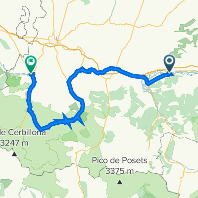
Day 4 - Circle from St-Gaudens (Estancarbon) to the South
This felt like a good recovery ride without our panniers. 'This easy ride included mostly low-traffic roads and two very gentle and not so high cols. They were the Col des Ares at 797M and the Col de Buret at 599M. Great scenery. D9 and D618 were both outstanding roads.
- -:--
- Duration
- 60.8 km
- Distance
- 741 m
- Ascent
- 741 m
- Descent
- ---
- Avg. speed
- ---
- Max. altitude

Route photos


Route quality
Waytypes & surfaces along the route
Waytypes
Road
16.4 km
(27 %)
Quiet road
1.8 km
(3 %)
Undefined
42.6 km
(70 %)
Surfaces
Paved
10.9 km
(18 %)
Asphalt
10.9 km
(18 %)
Undefined
49.9 km
(82 %)
Continue with Bikemap
Use, edit, or download this cycling route
You would like to ride 2019-04 St-Gaudens Circle to the South or customize it for your own trip? Here is what you can do with this Bikemap route:
Free features
- Save this route as favorite or in collections
- Copy & plan your own version of this route
- Sync your route with Garmin or Wahoo
Premium features
Free trial for 3 days, or one-time payment. More about Bikemap Premium.
- Navigate this route on iOS & Android
- Export a GPX / KML file of this route
- Create your custom printout (try it for free)
- Download this route for offline navigation
Discover more Premium features.
Get Bikemap PremiumFrom our community
Other popular routes starting in Saint-Gaudens
 Saint-Gaudens - AURIGNAC - MANCIOUX - ST GAUDENS
- Distance
- 59 km
- Ascent
- 386 m
- Descent
- 386 m
- Location
- Saint-Gaudens, Occitanie, France
 2013 Ride Day 30 - Estancarbon (St-Gaudens) to Tarbes
- Distance
- 92 km
- Ascent
- 874 m
- Descent
- 938 m
- Location
- Saint-Gaudens, Occitanie, France
 09-D. Saint-Gaudens - Plateau de Beille (169 Km)
- Distance
- 169 km
- Ascent
- 5,846 m
- Descent
- 4,459 m
- Location
- Saint-Gaudens, Occitanie, France
 2014 Ride Day 86 - St-Gaudens to l'Isle Jourdain
- Distance
- 98.1 km
- Ascent
- 361 m
- Descent
- 587 m
- Location
- Saint-Gaudens, Occitanie, France
 2019-04 St-Gaudens Circle to the South
- Distance
- 60.8 km
- Ascent
- 741 m
- Descent
- 741 m
- Location
- Saint-Gaudens, Occitanie, France
 2014 Ride Day 41 - St-Gaudens (Estancarbon) to Foix
- Distance
- 95.8 km
- Ascent
- 514 m
- Descent
- 498 m
- Location
- Saint-Gaudens, Occitanie, France
 R19 Saint Gaudens - TOURMALET - Lourdes
- Distance
- 136.4 km
- Ascent
- 2,821 m
- Descent
- 2,839 m
- Location
- Saint-Gaudens, Occitanie, France
 Tour de France - Etappe 14
- Distance
- 169.3 km
- Ascent
- 4,219 m
- Descent
- 2,796 m
- Location
- Saint-Gaudens, Occitanie, France
Open it in the app