

Bikepack
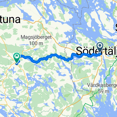
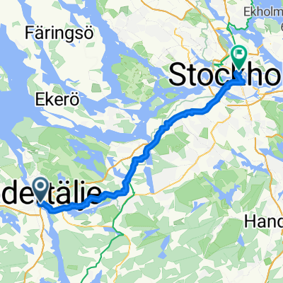
A cycling route starting in Södertälje, Stockholm County, Sweden.
Overview
About this route
- -:--
- Duration
- 279.3 km
- Distance
- 3,202 m
- Ascent
- 3,202 m
- Descent
- ---
- Avg. speed
- ---
- Max. altitude

Route highlights
Points of interest along the route
Accommodation after 15.3 km
Windshelter
Drinking water after 16 km
Food
Accommodation after 41.2 km
Windshelter
Drinking water after 55 km
Food
Accommodation after 63.4 km
Windshelter
Accommodation after 93.4 km
Windshelter
Accommodation after 97.5 km
Windshelter
Accommodation after 124.2 km
Youth Hostel
Drinking water after 124.2 km
Shops
Accommodation after 163 km
Windshelter
Accommodation after 187.5 km
Windshelter
Accommodation after 213.8 km
Windshelter
Accommodation after 215.5 km
Parking
Accommodation after 269.4 km
Windshelter
Continue with Bikemap
Use, edit, or download this cycling route
You would like to ride Bikepack or customize it for your own trip? Here is what you can do with this Bikemap route:
Free features
- Save this route as favorite or in collections
- Copy & plan your own version of this route
- Split it into stages to create a multi-day tour
- Sync your route with Garmin or Wahoo
Premium features
Free trial for 3 days, or one-time payment. More about Bikemap Premium.
- Navigate this route on iOS & Android
- Export a GPX / KML file of this route
- Create your custom printout (try it for free)
- Download this route for offline navigation
Discover more Premium features.
Get Bikemap PremiumFrom our community
Other popular routes starting in Södertälje
 Södertälje centrum naar Torggatan
- Distance
- 76.9 km
- Ascent
- 977 m
- Descent
- 936 m
- Location
- Södertälje, Stockholm County, Sweden

Edge 820®
Södertälje Cycling- Distance
- 27.5 km
- Ascent
- 345 m
- Descent
- 350 m
- Location
- Södertälje, Stockholm County, Sweden
 Vagnhärad - Stockholm
- Distance
- 39.9 km
- Ascent
- 430 m
- Descent
- 427 m
- Location
- Södertälje, Stockholm County, Sweden
 Kakslottet
- Distance
- 25.4 km
- Ascent
- 299 m
- Descent
- 326 m
- Location
- Södertälje, Stockholm County, Sweden
 Route von Östra Kanalgatan
- Distance
- 650.2 km
- Ascent
- 5,659 m
- Descent
- 5,593 m
- Location
- Södertälje, Stockholm County, Sweden
 Bikepack
- Distance
- 279.3 km
- Ascent
- 3,202 m
- Descent
- 3,202 m
- Location
- Södertälje, Stockholm County, Sweden
 season opening
- Distance
- 33.8 km
- Ascent
- 456 m
- Descent
- 457 m
- Location
- Södertälje, Stockholm County, Sweden
 Södertälje to Nygatan, Strängnäs
- Distance
- 57.5 km
- Ascent
- 587 m
- Descent
- 579 m
- Location
- Södertälje, Stockholm County, Sweden
Open it in the app