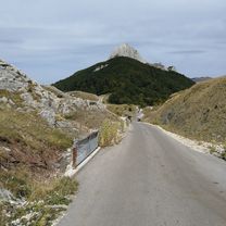
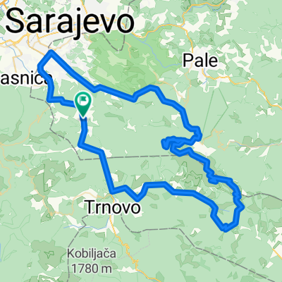
Babin Do - Konjic
A cycling route starting in Gračanica, Federation of Bosnia and Herzegovina, Bosnia and Herzegovina.
Overview
About this route
- -:--
- Duration
- 43.6 km
- Distance
- 566 m
- Ascent
- 1,565 m
- Descent
- ---
- Avg. speed
- ---
- Avg. speed
Route quality
Waytypes & surfaces along the route
Waytypes
Quiet road
32.1 km
(74 %)
Road
5.6 km
(13 %)
Surfaces
Paved
11.8 km
(27 %)
Unpaved
27.8 km
(64 %)
Gravel
27.8 km
(64 %)
Paved (undefined)
6.4 km
(15 %)
Continue with Bikemap
Use, edit, or download this cycling route
You would like to ride Babin Do - Konjic or customize it for your own trip? Here is what you can do with this Bikemap route:
Free features
- Save this route as favorite or in collections
- Copy & plan your own version of this route
- Sync your route with Garmin or Wahoo
Premium features
Free trial for 3 days, or one-time payment. More about Bikemap Premium.
- Navigate this route on iOS & Android
- Export a GPX / KML file of this route
- Create your custom printout (try it for free)
- Download this route for offline navigation
Discover more Premium features.
Get Bikemap PremiumFrom our community
Other popular routes starting in Gračanica
- Babin do 65, Bjelašnica to J5QM+8HC, Lukomir
- Distance
- 18.8 km
- Ascent
- 656 m
- Descent
- 476 m
- Location
- Gračanica, Federation of Bosnia and Herzegovina, Bosnia and Herzegovina
- Sabici-Rakitnica-Sinanovici-Sabici
- Distance
- 20.4 km
- Ascent
- 345 m
- Descent
- 330 m
- Location
- Gračanica, Federation of Bosnia and Herzegovina, Bosnia and Herzegovina
- Marsal - Sabici - Sinanovici i nazad
- Distance
- 36.9 km
- Ascent
- 828 m
- Descent
- 647 m
- Location
- Gračanica, Federation of Bosnia and Herzegovina, Bosnia and Herzegovina
- Oko Husremovca
- Distance
- 5.4 km
- Ascent
- 131 m
- Descent
- 145 m
- Location
- Gračanica, Federation of Bosnia and Herzegovina, Bosnia and Herzegovina
- lukomir
- Distance
- 18.8 km
- Ascent
- 608 m
- Descent
- 444 m
- Location
- Gračanica, Federation of Bosnia and Herzegovina, Bosnia and Herzegovina
- Treskavica
- Distance
- 74.9 km
- Ascent
- 2,031 m
- Descent
- 2,012 m
- Location
- Gračanica, Federation of Bosnia and Herzegovina, Bosnia and Herzegovina
- Šabići - Umoljani - Lukomir
- Distance
- 14.5 km
- Ascent
- 698 m
- Descent
- 403 m
- Location
- Gračanica, Federation of Bosnia and Herzegovina, Bosnia and Herzegovina
- bjelasnica vrh
- Distance
- 9.5 km
- Ascent
- 788 m
- Descent
- 6 m
- Location
- Gračanica, Federation of Bosnia and Herzegovina, Bosnia and Herzegovina