

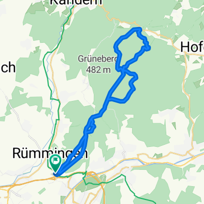
Mappach-Kandern
A cycling route starting in Rümmingen, Baden-Wurttemberg, Germany.
Overview
About this route
- 2 h 7 min
- Duration
- 42.7 km
- Distance
- 499 m
- Ascent
- 464 m
- Descent
- 20.1 km/h
- Avg. speed
- ---
- Max. altitude
Route quality
Waytypes & surfaces along the route
Waytypes
Quiet road
12.8 km
(30 %)
Road
8.1 km
(19 %)
Surfaces
Paved
25.2 km
(59 %)
Asphalt
22.6 km
(53 %)
Paved (undefined)
2.1 km
(5 %)
Continue with Bikemap
Use, edit, or download this cycling route
You would like to ride Mappach-Kandern or customize it for your own trip? Here is what you can do with this Bikemap route:
Free features
- Save this route as favorite or in collections
- Copy & plan your own version of this route
- Sync your route with Garmin or Wahoo
Premium features
Free trial for 3 days, or one-time payment. More about Bikemap Premium.
- Navigate this route on iOS & Android
- Export a GPX / KML file of this route
- Create your custom printout (try it for free)
- Download this route for offline navigation
Discover more Premium features.
Get Bikemap PremiumFrom our community
Other popular routes starting in Rümmingen
 Rund um Lörrach
- Distance
- 32.2 km
- Ascent
- 559 m
- Descent
- 509 m
- Location
- Rümmingen, Baden-Wurttemberg, Germany
 MTB-Tour Markgrafenland
- Distance
- 42 km
- Ascent
- 640 m
- Descent
- 639 m
- Location
- Rümmingen, Baden-Wurttemberg, Germany
 Rümmingen Kandern 10.09.25
- Distance
- 11.8 km
- Ascent
- 298 m
- Descent
- 211 m
- Location
- Rümmingen, Baden-Wurttemberg, Germany
 Kandern-Glasshütten-Lörach
- Distance
- 48 km
- Ascent
- 442 m
- Descent
- 468 m
- Location
- Rümmingen, Baden-Wurttemberg, Germany
 Hohe Strasse - Blauen
- Distance
- 52.8 km
- Ascent
- 1,529 m
- Descent
- 1,529 m
- Location
- Rümmingen, Baden-Wurttemberg, Germany
 LÖ Haagen-Hägelberg-Steinen-LÖ
- Distance
- 14 km
- Ascent
- 211 m
- Descent
- 207 m
- Location
- Rümmingen, Baden-Wurttemberg, Germany
 Tumringen - Glashütte - Tumringen
- Distance
- 22.8 km
- Ascent
- 441 m
- Descent
- 441 m
- Location
- Rümmingen, Baden-Wurttemberg, Germany
 Markgrafenstraße 12, Lörrach nach Bodenackerstraße 7, Lörrach
- Distance
- 45.3 km
- Ascent
- 824 m
- Descent
- 933 m
- Location
- Rümmingen, Baden-Wurttemberg, Germany
Open it in the app