

Slow ride in Oakland Park
A cycling route starting in Oakland Park, Florida, United States.
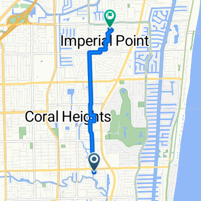
Overview
About this route
- 28 min
- Duration
- 9 km
- Distance
- 28 m
- Ascent
- 28 m
- Descent
- 19.6 km/h
- Avg. speed
- ---
- Max. altitude

Route quality
Waytypes & surfaces along the route
Waytypes
Quiet road
5.7 km
(63 %)
Road
1.7 km
(19 %)
Continue with Bikemap
Use, edit, or download this cycling route
You would like to ride Slow ride in Oakland Park or customize it for your own trip? Here is what you can do with this Bikemap route:
Free features
- Save this route as favorite or in collections
- Copy & plan your own version of this route
- Sync your route with Garmin or Wahoo
Premium features
Free trial for 3 days, or one-time payment. More about Bikemap Premium.
- Navigate this route on iOS & Android
- Export a GPX / KML file of this route
- Create your custom printout (try it for free)
- Download this route for offline navigation
Discover more Premium features.
Get Bikemap PremiumFrom our community
Other popular routes starting in Oakland Park
 East Oakland Park Boulevard 1920, Fort Lauderdale to Northwest 3rd Avenue 1601, Fort Lauderdale
- Distance
- 4.8 km
- Ascent
- 11 m
- Descent
- 14 m
- Location
- Oakland Park, Florida, United States
 Northeast 27th Way 2601, Fort Lauderdale to Bayview Drive 2617, Fort Lauderdale
- Distance
- 13 km
- Ascent
- 26 m
- Descent
- 18 m
- Location
- Oakland Park, Florida, United States
 Slow ride in Oakland Park
- Distance
- 9 km
- Ascent
- 28 m
- Descent
- 28 m
- Location
- Oakland Park, Florida, United States
 HUGH TAYLOR STATE PARK
- Distance
- 5.5 km
- Ascent
- 43 m
- Descent
- 43 m
- Location
- Oakland Park, Florida, United States
 4321 NE 16th Ave, Oakland Park to 2–22 Commercial Blvd, Lauderdale-by-the-Sea
- Distance
- 4 km
- Ascent
- 8 m
- Descent
- 7 m
- Location
- Oakland Park, Florida, United States
 Northeast 26th Street 2016, Wilton Manors to Northeast 26th Street 1417, Wilton Manors
- Distance
- 15.9 km
- Ascent
- 20 m
- Descent
- 16 m
- Location
- Oakland Park, Florida, United States
 Elise
Elise- Distance
- 4.9 km
- Ascent
- 4 m
- Descent
- 4 m
- Location
- Oakland Park, Florida, United States
 3101 SR-5 S, Oakland Park to 1317 NW Seventh Ave, Fort Lauderdale
- Distance
- 7.2 km
- Ascent
- 0 m
- Descent
- 0 m
- Location
- Oakland Park, Florida, United States
Open it in the app