

BAD VÖSLAU und UMGEBUNG
Bad Vöslau - Helenental - Heiligenkreuz - Rosental
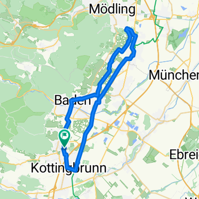
A cycling route starting in Bad Vöslau, Lower Austria, Austria.
Overview
About this route
The start and end point is the VIVEA health hotel! The tour initially leads to Sooß and from there to Baden to the Helenental bike path. Along this route, you follow the Schwechat River upstream to Sattelbach. Here you turn right heading north towards Heiligenkreuz. After a brief 'outside-only' visit to the Cistercian monastery, the route continues along the 'Helenental route' around the large Bodenberg to Siegenfeld, then down through the Rosental valley back to Helenental. On the Helenental bike path, you return along the same route back to Bad Vöslau!
- -:--
- Duration
- 33.3 km
- Distance
- 232 m
- Ascent
- 229 m
- Descent
- ---
- Avg. speed
- ---
- Max. altitude

Part of
4 stages
Route quality
Waytypes & surfaces along the route
Waytypes
Cycleway
11.7 km
(35 %)
Quiet road
8.3 km
(25 %)
Surfaces
Paved
22.3 km
(67 %)
Unpaved
5.7 km
(17 %)
Asphalt
19 km
(57 %)
Pebblestone
3 km
(9 %)
Continue with Bikemap
Use, edit, or download this cycling route
You would like to ride Bad Vöslau - Helenental - Heiligenkreuz - Rosental or customize it for your own trip? Here is what you can do with this Bikemap route:
Free features
- Save this route as favorite or in collections
- Copy & plan your own version of this route
- Sync your route with Garmin or Wahoo
Premium features
Free trial for 3 days, or one-time payment. More about Bikemap Premium.
- Navigate this route on iOS & Android
- Export a GPX / KML file of this route
- Create your custom printout (try it for free)
- Download this route for offline navigation
Discover more Premium features.
Get Bikemap PremiumFrom our community
Other popular routes starting in Bad Vöslau
 Leitha-Runde
- Distance
- 52 km
- Ascent
- 100 m
- Descent
- 100 m
- Location
- Bad Vöslau, Lower Austria, Austria
 Wien & Kulturtour 35km
- Distance
- 35.5 km
- Ascent
- 120 m
- Descent
- 117 m
- Location
- Bad Vöslau, Lower Austria, Austria
 Bad Vöslau Dreistetten
- Distance
- 72.7 km
- Ascent
- 1,136 m
- Descent
- 1,112 m
- Location
- Bad Vöslau, Lower Austria, Austria
 Lange Ausfahrt über Lindkogl
- Distance
- 61.5 km
- Ascent
- 1,382 m
- Descent
- 1,401 m
- Location
- Bad Vöslau, Lower Austria, Austria
 Sooß Großau Vöslau Sooß
- Distance
- 21.3 km
- Ascent
- 204 m
- Descent
- 203 m
- Location
- Bad Vöslau, Lower Austria, Austria
 2020-04-28 3:31 Hoher Lindkogel
- Distance
- 30 km
- Ascent
- 1,050 m
- Descent
- 1,032 m
- Location
- Bad Vöslau, Lower Austria, Austria
 Vöslau - Guntramsdorf R51+EV9a Rundweg
- Distance
- 39.9 km
- Ascent
- 99 m
- Descent
- 99 m
- Location
- Bad Vöslau, Lower Austria, Austria
 Tour R24
- Distance
- 17.6 km
- Ascent
- 569 m
- Descent
- 571 m
- Location
- Bad Vöslau, Lower Austria, Austria
Open it in the app