
1
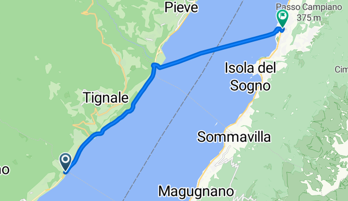
A cycling route starting in Gardola, Lombardy, Italy.
Overview
About this route
- 1 h 16 min
- Duration
- 11.5 km
- Distance
- 0 m
- Ascent
- 0 m
- Descent
- 9 km/h
- Avg. speed
- ---
- Max. altitude
Continue with Bikemap
Use, edit, or download this cycling route
You would like to ride 1 or customize it for your own trip? Here is what you can do with this Bikemap route:
Free features
- Save this route as favorite or in collections
- Copy & plan your own version of this route
- Sync your route with Garmin or Wahoo
Premium features
Free trial for 3 days, or one-time payment. More about Bikemap Premium.
- Navigate this route on iOS & Android
- Export a GPX / KML file of this route
- Create your custom printout (try it for free)
- Download this route for offline navigation
Discover more Premium features.
Get Bikemap PremiumFrom our community
Other popular routes starting in Gardola
 Cima Tignale Hard Rock Trail
- Distance
- 27.6 km
- Ascent
- 1,170 m
- Descent
- 1,170 m
- Location
- Gardola, Lombardy, Italy
 1
1- Distance
- 11.5 km
- Ascent
- 0 m
- Descent
- 0 m
- Location
- Gardola, Lombardy, Italy
 Aufnahme vom 17.04.2017, 14:46
- Distance
- 106.3 km
- Ascent
- 1,700 m
- Descent
- 1,776 m
- Location
- Gardola, Lombardy, Italy
 Cima di Tignale
- Distance
- 26.8 km
- Ascent
- 1,189 m
- Descent
- 1,192 m
- Location
- Gardola, Lombardy, Italy
 Pas Tremalzo
- Distance
- 70.2 km
- Ascent
- 2,123 m
- Descent
- 2,127 m
- Location
- Gardola, Lombardy, Italy
 Tignale - Vesio Passo Nota
- Distance
- 45 km
- Ascent
- 1,215 m
- Descent
- 1,220 m
- Location
- Gardola, Lombardy, Italy
 cima di tignale
- Distance
- 24.5 km
- Ascent
- 1,184 m
- Descent
- 1,212 m
- Location
- Gardola, Lombardy, Italy
 l.di Garda - Tignale
- Distance
- 27.9 km
- Ascent
- 978 m
- Descent
- 997 m
- Location
- Gardola, Lombardy, Italy
Open it in the app