

519. "Klausenpass und Ober Nas" (Teil 2 von 3)
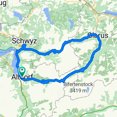
A cycling route starting in Altdorf, Canton of Uri, Switzerland.
Overview
About this route
- ridden on Wed, 18.09.2019 at 10 to 16°C
- With parts 1 and 3 109 km
- climbing from about 1200m to 1700m in cloud, above sunny mountain world - steep in Bürglen, through Spiringen and almost permanently 10% from Unterschächen, almost serpentine-free, long ramps - in descent 10%-serpentines to Linthal with almost horizontal section Urner Boden - in part 3 ride from Bf Arth-Goldau at Lake Zug to Küssnacht, then (not flat) along Lake Lucerne over Ober Nas to Brunnen - train rides: Brunnen - Altdorf / Glarus - Pfäffikon (each SBB) + Pfäffikon - Arth-Goldau ('Voralpenexpress' of the Südostbahn)
- -:--
- Duration
- 65.2 km
- Distance
- 1,555 m
- Ascent
- 1,532 m
- Descent
- ---
- Avg. speed
- ---
- Max. altitude
Route quality
Waytypes & surfaces along the route
Waytypes
Quiet road
4.6 km
(7 %)
Road
1.3 km
(2 %)
Surfaces
Paved
59.3 km
(91 %)
Unpaved
0.7 km
(1 %)
Asphalt
59.3 km
(91 %)
Loose gravel
0.7 km
(1 %)
Undefined
5.2 km
(8 %)
Continue with Bikemap
Use, edit, or download this cycling route
You would like to ride 519. "Klausenpass und Ober Nas" (Teil 2 von 3) or customize it for your own trip? Here is what you can do with this Bikemap route:
Free features
- Save this route as favorite or in collections
- Copy & plan your own version of this route
- Sync your route with Garmin or Wahoo
Premium features
Free trial for 3 days, or one-time payment. More about Bikemap Premium.
- Navigate this route on iOS & Android
- Export a GPX / KML file of this route
- Create your custom printout (try it for free)
- Download this route for offline navigation
Discover more Premium features.
Get Bikemap PremiumFrom our community
Other popular routes starting in Altdorf
 Klausenpass_Pragelpass
- Distance
- 130.9 km
- Ascent
- 2,641 m
- Descent
- 2,641 m
- Location
- Altdorf, Canton of Uri, Switzerland
 Isenthal Bike - 403 SchweizMobil
- Distance
- 34.2 km
- Ascent
- 1,582 m
- Descent
- 1,396 m
- Location
- Altdorf, Canton of Uri, Switzerland
 Klausenpass + Pragelpass (Altdorf)
- Distance
- 129.8 km
- Ascent
- 2,653 m
- Descent
- 2,656 m
- Location
- Altdorf, Canton of Uri, Switzerland
 519. "Klausenpass und Ober Nas" (Teil 2 von 3)
- Distance
- 65.2 km
- Ascent
- 1,555 m
- Descent
- 1,532 m
- Location
- Altdorf, Canton of Uri, Switzerland
 Altdorf - Göscheneralp
- Distance
- 40.1 km
- Ascent
- 1,384 m
- Descent
- 50 m
- Location
- Altdorf, Canton of Uri, Switzerland
 008 Altdorf - Willerzell, SA 01.08.20
- Distance
- 47.7 km
- Ascent
- 905 m
- Descent
- 473 m
- Location
- Altdorf, Canton of Uri, Switzerland
 klausen pass Pragel pass
- Distance
- 130.4 km
- Ascent
- 2,809 m
- Descent
- 2,809 m
- Location
- Altdorf, Canton of Uri, Switzerland
 Route«1291» Etappe 2: Altdorf – Andermatt
- Distance
- 37 km
- Ascent
- 1,082 m
- Descent
- 109 m
- Location
- Altdorf, Canton of Uri, Switzerland
Open it in the app